Photo Mug > Europe > France > Canton > Landes
Photo Mug : Battle of Bull Run


![]()
Home Decor from Fine Art Storehouse
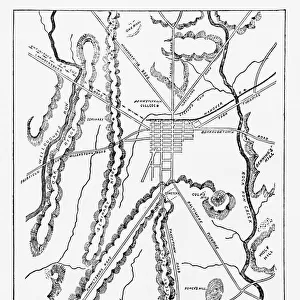
Battle of Bull Run
Vintage engraving from 1863 of a map of Bull Run and its environs at the time of the American Civil War. The First Battle of Bull Run, also known as the First Battle of Manassas (the name used by Confederate forces), was fought on July 21, 1861, in Prince William County, Virginia, near the City of Manassas. It was the first major land battle of the American Civil War. And resulted in a Confederate victory
Unleash your creativity and transform your space into a visual masterpiece!
duncan1890
Media ID 15244031
© duncan1890
American Civil War American Culture Army Battle Battlefield Chart Civil War Conflict Document Eastern Usa Historical War Event Illustrations And Vector Art Image Created 1860 1869 Information Equipment Mid Atlantic Usa Military Navigational Equipment North America Objects Equipment Past Plan Printed Media Styles Traditional Culture Travel Locations Virginia Bull Run Fairfax Fairfax County Image Created 19th Century Obsolete
Photo Mug
Add history to your daily routine with our Media Storehouse Photo Mug featuring the iconic Battle of Bull Run engraving by duncan1890 from Fine Art Storehouse. This vintage 1863 map of Bull Run and its surroundings, depicting the site of the First Battle of Bull Run during the American Civil War, is now available in mug form. Each sip brings you closer to history as you enjoy your favorite beverage. Order yours today and start your day with a dose of history!
A personalised photo mug blends sentimentality with functionality, making an ideal gift for cherished loved ones, close friends, or valued colleagues. Preview may show both sides of the same mug.
Elevate your coffee or tea experience with our premium white ceramic mug. Its wide, comfortable handle makes drinking easy, and you can rely on it to be both microwave and dishwasher safe. Sold in single units, preview may show both sides of the same mug so you can see how the picture wraps around.
Mug Size is 9.6cm high x 8.1cm diameter (3.8" x 3.2")
These are individually made so all sizes are approximate
FEATURES IN THESE COLLECTIONS
> Fine Art Storehouse
> History
> Battles & Wars
> American Civil War (1860-1865)
> Fine Art Storehouse
> History
> Battles & Wars
> Historcal Battle Maps and Plans
> Fine Art Storehouse
> Map
> Historical Maps
> Fine Art Storehouse
> Map
> Map Illustrations
> Fine Art Storehouse
> Map
> USA Maps
> Europe
> France
> Canton
> Landes
> Historic
> Battles
> Related Images
> Maps and Charts
> Early Maps
> Maps and Charts
> Related Images
> North America
> Related Images
> North America
> United States of America
> Maps
> North America
> United States of America
> Virginia
> Related Images
EDITORS COMMENTS
This vintage engraving from 1863 captures the Battle of Bull Run, a pivotal moment in American history during the Civil War. The detailed map showcases Bull Run and its surroundings at the time, providing a glimpse into the strategic importance of this region. The First Battle of Bull Run, also known as the First Battle of Manassas by Confederate forces, took place on July 21,1861, in Prince William County, Virginia. As one examines this antique woodcut image with its intricate engravings and old-fashioned style, it transports us back to a time when conflict shaped our nation's destiny. This print serves as a testament to both the obsolete nature of engraved images and their enduring historical significance. The battle itself resulted in a Confederate victory and marked an important milestone in military strategy for both sides. It was here that armies clashed for control over key territories in Fairfax County while shaping the course of future battles throughout America's mid-Atlantic region. This illustration not only offers insight into past military tactics but also provides valuable information about American culture during this era. As we study this piece closely, we can appreciate how printed media like maps played an essential role in conveying vital information to soldiers on navigational equipment or charts. Duncan1890's photograph reminds us of our rich history and invites us to reflect upon those who fought bravely on these hallowed grounds so many years ago.
MADE IN AUSTRALIA
Safe Shipping with 30 Day Money Back Guarantee
FREE PERSONALISATION*
We are proud to offer a range of customisation features including Personalised Captions, Color Filters and Picture Zoom Tools
SECURE PAYMENTS
We happily accept a wide range of payment options so you can pay for the things you need in the way that is most convenient for you
* Options may vary by product and licensing agreement. Zoomed Pictures can be adjusted in the Cart.