Photo Mug : 1837, Malte-Brun Map of Ancient Egypt, Nubia, Sudan and Abyssinia, Ethiopia, topography


![]()
Home Decor from Liszt Collection
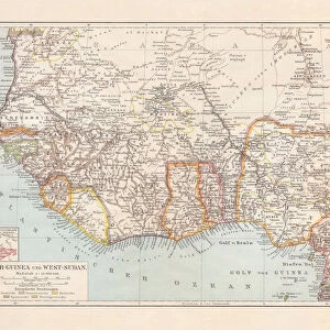
1837, Malte-Brun Map of Ancient Egypt, Nubia, Sudan and Abyssinia, Ethiopia, topography
1837, Malte-Brun Map of Ancient Egypt, Nubia, Sudan and Abyssinia, Ethiopia
Liszt Collection of nineteenth-century engravings and images to browse and enjoy
Media ID 14005063
© Artokoloro Quint Lox Limited
1837 Ethiopia Nubia Antique Map Latitude Longitude Mappa Mundi Old Antique Plan Old Antique View Ols Antique Map Rare Old Maps Topo
Photo Mug
Step back in time with our unique Media Storehouse Photo Mug, featuring the captivating 1837 Malte-Brun Map of Ancient Egypt, Nubia, Sudan, and Abyssinia, Ethiopia. This topographical map, sourced from the esteemed Liszt Collection, showcases intricate details of the region's historical geography. Each sip from this mug brings a piece of history to your daily routine, making it an exceptional gift for history enthusiasts or anyone who appreciates the beauty of vintage maps. Embrace the past, one mug at a time.
A personalised photo mug blends sentimentality with functionality, making an ideal gift for cherished loved ones, close friends, or valued colleagues. Preview may show both sides of the same mug.
Elevate your coffee or tea experience with our premium white ceramic mug. Its wide, comfortable handle makes drinking easy, and you can rely on it to be both microwave and dishwasher safe. Sold in single units, preview may show both sides of the same mug so you can see how the picture wraps around.
Mug Size is 9.6cm high x 8.1cm diameter (3.8" x 3.2")
These are individually made so all sizes are approximate
EDITORS COMMENTS
This print showcases the remarkable 1837 Malte-Brun Map of Ancient Egypt, Nubia, Sudan and Abyssinia, Ethiopia. A true treasure for cartography enthusiasts and history buffs alike, this topographical masterpiece offers a glimpse into the ancient world with its intricate details and meticulous craftsmanship. The map's rich illustration beautifully captures the geographic features of these regions, providing an invaluable resource for travelers and explorers of that era. Its carefully plotted grid lines reveal latitude and longitude coordinates, allowing users to navigate through the vast lands with ease. As a vintage piece of art on aged paper, this historic map exudes an aura of authenticity that transports us back in time. Its decorative elements add to its charm while evoking a sense of wonder about the journeys undertaken by early adventurers. With its historical significance and rare nature, this antique map is not only a visual delight but also serves as a valuable educational tool. It sheds light on ancient civilizations' understanding of their surroundings while offering insights into how our knowledge has evolved over time. Whether displayed in homes or offices, this stunning print from the Liszt Collection sparks curiosity about our planet's past while celebrating human ingenuity in mapping uncharted territories.
MADE IN AUSTRALIA
Safe Shipping with 30 Day Money Back Guarantee
FREE PERSONALISATION*
We are proud to offer a range of customisation features including Personalised Captions, Color Filters and Picture Zoom Tools
SECURE PAYMENTS
We happily accept a wide range of payment options so you can pay for the things you need in the way that is most convenient for you
* Options may vary by product and licensing agreement. Zoomed Pictures can be adjusted in the Cart.