Photo Mug > Europe > France > Canton > Landes
Photo Mug : 1864, Garnier Map of Pairs, France w-Monuments, topography, cartography, geography


![]()
Home Decor from Liszt Collection
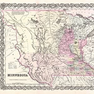
1864, Garnier Map of Pairs, France w-Monuments, topography, cartography, geography
1864, Garnier Map of Pairs, France w-Monuments
Liszt Collection of nineteenth-century engravings and images to browse and enjoy
Media ID 14006000
© Artokoloro Quint Lox Limited
1864 Antique Map Latitude Longitude Mappa Mundi Old Antique Plan Old Antique View Ols Antique Map Rare Old Maps Topo
Photo Mug
Step back in time with our Media Storehouse Photo Mug featuring the historic 1864 Garnier Map of Paris, France. This beautiful collectible mug showcases intricate details of the city's monuments, topography, cartography, and geography from the renowned Liszt Collection. Each sip brings a journey through Parisian history, making it a perfect gift for history enthusiasts, map collectors, or anyone who appreciates the beauty of vintage maps. Embrace the past, savor your favorite beverage, and add a touch of timeless charm to your daily routine.
A personalised photo mug blends sentimentality with functionality, making an ideal gift for cherished loved ones, close friends, or valued colleagues. Preview may show both sides of the same mug.
Elevate your coffee or tea experience with our premium white ceramic mug. Its wide, comfortable handle makes drinking easy, and you can rely on it to be both microwave and dishwasher safe. Sold in single units, preview may show both sides of the same mug so you can see how the picture wraps around.
Mug Size is 8.1cm high x 9.6cm diameter (3.2" x 3.8")
These are individually made so all sizes are approximate
FEATURES IN THESE COLLECTIONS
> Europe
> France
> Canton
> Landes
> Historic
> Monuments and landmarks
> Monuments and memorials
> Historic
> Space exploration
> Maps and Charts
> Early Maps
> Maps and Charts
> Related Images
> Maps and Charts
> World
EDITORS COMMENTS
This print showcases the remarkable 1864 Garnier Map of Paris, France. A true masterpiece of cartography, this vintage map not only provides a detailed depiction of the city's topography and geography but also highlights its rich history through the inclusion of numerous monuments and landmarks. The intricate illustration on this old paper exudes an air of elegance and sophistication, transporting viewers back in time to a bygone era. Its decorative elements, such as the artistic rendering of landforms and use of latitude and longitude grids, add both beauty and functionality to this historic piece. As one gazes upon this rare antique map, they are taken on a visual journey through space and time. It serves as a window into the past, offering insights into how Paris looked centuries ago. The careful craftsmanship evident in every line and curve is a testament to the skillful artistry that went into creating such maps during that period. Whether you are an avid collector or simply appreciate historical artifacts, this Garnier Map print is sure to captivate your imagination. Its presence adds character to any space while serving as a reminder of our ever-evolving world. Let it transport you back in time as you explore Paris' geographical wonders from the comfort of your own home.
MADE IN AUSTRALIA
Safe Shipping with 30 Day Money Back Guarantee
FREE PERSONALISATION*
We are proud to offer a range of customisation features including Personalised Captions, Color Filters and Picture Zoom Tools
SECURE PAYMENTS
We happily accept a wide range of payment options so you can pay for the things you need in the way that is most convenient for you
* Options may vary by product and licensing agreement. Zoomed Pictures can be adjusted in the Cart.