Photo Mug > Europe > United Kingdom > England > London > Museums > London Canal Museum
Photo Mug : First geological map of Britain, 1815 C016 / 5683


![]()
Home Decor from Science Photo Library
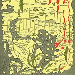
First geological map of Britain, 1815 C016 / 5683
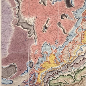
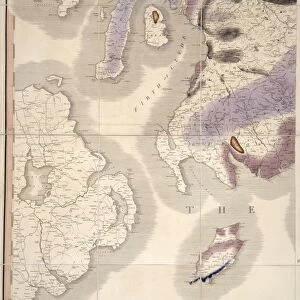
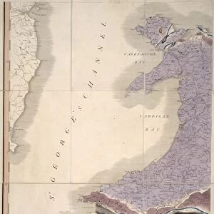
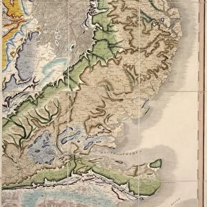
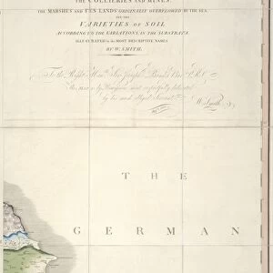
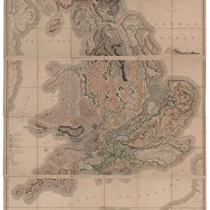
First geological map of Britain, detail of the north east coast (figure 8). This map was published in 1815 by British geologist William Smith (1769-1839). It shows rock layers (strata) in England and Wales and part of Scotland (key at lower left). Smiths work as a canal surveyor allowed him to study geology. He discovered that geological strata could be reliably identified at different places on the basis of the fossils they contained. Smith also proposed the principle of superposition, that if a strata overlays another then it was laid down at a later time. He is considered the father of English geology
Science Photo Library features Science and Medical images including photos and illustrations
Media ID 9206565
© NATURAL HISTORY MUSEUM, LONDON/SCIENCE PHOTO LIBRARY
1815 Cartography Coast Coastal Country Earth Science Geological Great Britain North East Pioneering Region Scottish Strata Stratigraphy Stratum Superposition Welsh William Smith
Photo Mug
Introducing the Media Storehouse Photo Mug, featuring an intriguing image from the annals of geological history. This exquisite mug showcases a detailed portion of the "First Geological Map of Britain," published in 1815 by the renowned British geologist, William Smith. The image, sourced from the Natural History Museum in London via Science Photo Library, offers a captivating glimpse into the early days of geological mapping. Each sip from this mug brings you closer to the history of geology, making it an excellent conversation starter or a thoughtful gift for those with a passion for geology or history. Embrace the beauty of science and history with every use.
A personalised photo mug blends sentimentality with functionality, making an ideal gift for cherished loved ones, close friends, or valued colleagues. Preview may show both sides of the same mug.
Elevate your coffee or tea experience with our premium white ceramic mug. Its wide, comfortable handle makes drinking easy, and you can rely on it to be both microwave and dishwasher safe. Sold in single units, preview may show both sides of the same mug so you can see how the picture wraps around.
Mug Size is 9.6cm high x 8.1cm diameter (3.8" x 3.2")
These are individually made so all sizes are approximate
FEATURES IN THESE COLLECTIONS
> Asia
> East Timor
> Maps
> Asia
> East Timor
> Related Images
> Europe
> United Kingdom
> England
> London
> Museums
> British Library
> Europe
> United Kingdom
> England
> London
> Museums
> British Museum
> Europe
> United Kingdom
> England
> London
> Museums
> London Canal Museum
> Europe
> United Kingdom
> England
> London
> Museums
> Natural History Museum
> Europe
> United Kingdom
> England
> London
> Museums
> Science Museum
> Europe
> United Kingdom
> England
> London
> Sights
> British Museum
> Europe
> United Kingdom
> England
> London
> Sights
> London Canal Museum
> Europe
> United Kingdom
> England
> London
> Towns
> Lower Place
EDITORS COMMENTS
This print showcases the first geological map of Britain, a groundbreaking work published in 1815 by British geologist William Smith. The map, displayed here in detail of the north east coast (figure 8), provides a comprehensive depiction of rock layers (strata) found across England and Wales, as well as part of Scotland. William Smith's remarkable contribution to geology stemmed from his earlier career as a canal surveyor. Through his meticulous observations, he discovered that different geological strata could be reliably identified based on the fossils they contained. This revolutionary insight allowed for accurate mapping and understanding of Earth's history. Smith also proposed the principle of superposition, which states that if one layer overlays another, it was deposited at a later time. This concept became fundamental to stratigraphy and further solidified Smith's status as the father of English geology. The intricate illustration captures not only the geographical features but also includes a key at the lower left corner explaining various rock formations present in different regions. Its publication marked an important milestone in earth science and cartography during the early 19th century. Preserved by NATURAL HISTORY MUSEUM, LONDON/SCIENCE PHOTO LIBRARY, this artwork serves as an invaluable historical artifact showcasing pioneering research that laid the foundation for modern geological studies.
MADE IN AUSTRALIA
Safe Shipping with 30 Day Money Back Guarantee
FREE PERSONALISATION*
We are proud to offer a range of customisation features including Personalised Captions, Color Filters and Picture Zoom Tools
SECURE PAYMENTS
We happily accept a wide range of payment options so you can pay for the things you need in the way that is most convenient for you
* Options may vary by product and licensing agreement. Zoomed Pictures can be adjusted in the Cart.