Photographic Print > North America > United States of America > Maps
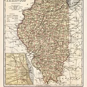
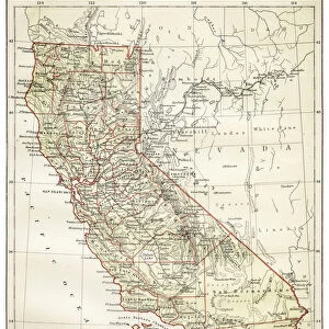
Photographic Print : Indiana USA map 1881


![]()
Photo Prints from Fine Art Storehouse
Indiana USA map 1881
Encyclopedia Britannica 9th Edition Vol XII Philadelphia j.M. Stoddart & Co 1881
Unleash your creativity and transform your space into a visual masterpiece!
THEPALMER
Media ID 13611527
© This content is subject to copyright
Indiana North America Paper State World Map
10"x8" (25x20cm) Photo Print
Transport yourself back in time with our exquisite 'Indiana USA Map 1881' print from THEPALMER's Fine Art Storehouse collection. This captivating piece, inspired by the Encyclopedia Britannica 9th Edition Vol XII published by J.M. Stoddart & Co in 1881, showcases an intricately detailed map of Indiana during that era. Bring history into your home or office with this stunning vintage artwork that not only serves as a decorative piece but also as an educational and conversational piece. Experience the charm of the past with our high-quality photographic print.
Ideal for framing, Australian made Photo Prints are produced on high-quality 270 gsm lustre photo paper which has a subtle shimmer adding a touch of elegance, designed to enhance their visual appeal.
Our Photo Prints are in a large range of sizes and are printed on Archival Quality Paper for excellent colour reproduction and longevity. They are ideal for framing (our Framed Prints use these) at a reasonable cost. Alternatives include cheaper Poster Prints and higher quality Fine Art Paper, the choice of which is largely dependant on your budget.
Estimated Product Size is 20.3cm x 25.4cm (8" x 10")
These are individually made so all sizes are approximate
Artwork printed orientated as per the preview above, with landscape (horizontal) or portrait (vertical) orientation to match the source image.
FEATURES IN THESE COLLECTIONS
> Fine Art Storehouse
> The Magical World of Illustration
> Palmer Illustrated Collection
> Fine Art Storehouse
> Map
> Historical Maps
> Fine Art Storehouse
> Map
> USA Maps
> Maps and Charts
> Related Images
> Maps and Charts
> World
> North America
> Related Images
> North America
> United States of America
> Indiana
> Related Images
> North America
> United States of America
> Maps
EDITORS COMMENTS
This print takes us back in time to the year 1881, showcasing an exquisite map of Indiana, USA. A relic from the Encyclopedia Britannica's 9th Edition, Volume XII, this piece was published by J. M. Stoddart & Co in Philadelphia during a period when cartography was still an art form. The intricate details and craftsmanship evident in this vertical depiction of Indiana transport us to a bygone era. The aged paper adds character and authenticity to the print, reminding us of its historical significance. As we gaze upon this antique engraving turned illustration, we are reminded of the importance placed on physical geography at that time. Every contour and boundary is meticulously etched onto the map with precision and care. Indiana's place within North America becomes apparent as it stands proudly amidst its neighboring states on this world map. Its position signifies not only its geographical location but also its role within American history. "The Palmer" whose name graces this remarkable artwork, has captured more than just a simple representation of landmasses; they have encapsulated an entire era through their lens or brushstroke. This photograph transports us into a different time altogether – one where exploration and discovery were paramount. As we admire "Indiana USA Map 1881" let us appreciate both the beauty of cartography as an art form and our ability to glimpse into history through such extraordinary pieces preserved for generations to come.
MADE IN AUSTRALIA
Safe Shipping with 30 Day Money Back Guarantee
FREE PERSONALISATION*
We are proud to offer a range of customisation features including Personalised Captions, Color Filters and Picture Zoom Tools
SECURE PAYMENTS
We happily accept a wide range of payment options so you can pay for the things you need in the way that is most convenient for you
* Options may vary by product and licensing agreement. Zoomed Pictures can be adjusted in the Cart.