Photographic Print > Arts > Minimalist artwork > Monochrome artwork > Fine art
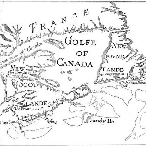
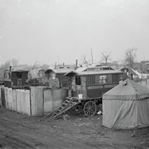
Photographic Print : Map of County Kerry, Ireland, 1924-1926


![]()
Photo Prints from Heritage Images
Map of County Kerry, Ireland, 1924-1926
Map of County Kerry, Ireland, 1924-1926. A print from Hutchinsons Britain Beautiful, edited by Walter Hutchinson, volume II, 1924-1926
Heritage Images features heritage image collections
Media ID 14943746
© The Print Collector / Heritage-Images
Cartography County County Kerry Ireland Irish Kerry Map Making Munster Print Collector8
10"x8" (25x20cm) Photo Print
Step back in time with our vintage Map of County Kerry, Ireland, from 1924-1926. This beautiful photographic print, sourced from Heritage Images, is taken from Hutchinsons Britain Beautiful, edited by Walter Hutchinson. Add an historic touch to your home or office decor with this intricately detailed map, showcasing County Kerry's geography during this era. A must-have for history enthusiasts and those with Irish heritage.
Ideal for framing, Australian made Photo Prints are produced on high-quality 270 gsm lustre photo paper which has a subtle shimmer adding a touch of elegance, designed to enhance their visual appeal.
Our Photo Prints are in a large range of sizes and are printed on Archival Quality Paper for excellent colour reproduction and longevity. They are ideal for framing (our Framed Prints use these) at a reasonable cost. Alternatives include cheaper Poster Prints and higher quality Fine Art Paper, the choice of which is largely dependant on your budget.
Estimated Product Size is 25.4cm x 20.3cm (10" x 8")
These are individually made so all sizes are approximate
Artwork printed orientated as per the preview above, with landscape (horizontal) or portrait (vertical) orientation to match the source image.
FEATURES IN THESE COLLECTIONS
> Arts
> Minimalist artwork
> Monochrome artwork
> Fine art
> Arts
> Minimalist artwork
> Monochrome artwork
> Monochrome paintings
> Europe
> Republic of Ireland
> Maps
> Maps and Charts
> Related Images
EDITORS COMMENTS
This print showcases a meticulously detailed map of County Kerry, Ireland, dating back to the years 1924-1926. A true treasure from the early 20th century, this vintage piece is taken from Hutchinsons Britain Beautiful, edited by Walter Hutchinson in volume II. The monochrome aesthetic adds an air of nostalgia to this cartographic masterpiece, highlighting the intricate geography and location of County Kerry within the larger Irish landscape. As one explores this map, they are transported back in time to witness how this enchanting region appeared nearly a century ago. With its rich history and cultural significance, County Kerry emerges as a focal point on this map. Situated in Munster province, it reveals not only the county's boundaries but also offers insights into its diverse topography and landmarks that have shaped its identity over centuries. Although created by an unknown artist or cartographer, their expertise shines through every line and contour depicted on this print. The attention to detail is awe-inspiring; each village, townland, river course has been meticulously recorded for posterity. As we delve into the past through this image of County Kerry's map from 1924-1926 - courtesy of The Print Collector - we are reminded of both our connection with history and our ever-changing world.
MADE IN AUSTRALIA
Safe Shipping with 30 Day Money Back Guarantee
FREE PERSONALISATION*
We are proud to offer a range of customisation features including Personalised Captions, Color Filters and Picture Zoom Tools
SECURE PAYMENTS
We happily accept a wide range of payment options so you can pay for the things you need in the way that is most convenient for you
* Options may vary by product and licensing agreement. Zoomed Pictures can be adjusted in the Cart.