Photographic Print > Europe > United Kingdom > England > London > Sights > Heathrow Airport
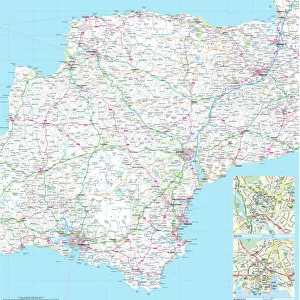
Photographic Print : 100 Miles Around London Map


![]()
Photo Prints from Map Marketing
100 Miles Around London Map
A clear map covering a 100-mile radius around London. Specially produced for the commercial driver and practical motorist, designed for planning of sales and transportation within a 100-mile radius of London. Roads are colour-coded for easy use, road numbers and distances are shown in a format that is clear and easy to read. Also includes county boundaries, airports and ferry routes. The area covered is from Bristol to the East coast and from Stoke-on-Trent to the South coast
Media ID 19949535
© Map Marketing Ltd
10"x8" (25x20cm) Photo Print
Ideal for framing, Australian made Photo Prints are produced on high-quality 270 gsm lustre photo paper which has a subtle shimmer adding a touch of elegance, designed to enhance their visual appeal.
Our Photo Prints are in a large range of sizes and are printed on Archival Quality Paper for excellent colour reproduction and longevity. They are ideal for framing (our Framed Prints use these) at a reasonable cost. Alternatives include cheaper Poster Prints and higher quality Fine Art Paper, the choice of which is largely dependant on your budget.
Estimated Product Size is 25.4cm x 20.3cm (10" x 8")
These are individually made so all sizes are approximate
Artwork printed orientated as per the preview above, with landscape (horizontal) orientation to match the source image.
FEATURES IN THESE COLLECTIONS
> Europe
> United Kingdom
> England
> Bristol
> Bristol
> Europe
> United Kingdom
> England
> London
> Sights
> Heathrow Airport
> Europe
> United Kingdom
> England
> Maps
> Europe
> United Kingdom
> England
> Stoke-on-Trent
> Maps and Charts
> Related Images
MADE IN AUSTRALIA
Safe Shipping with 30 Day Money Back Guarantee
FREE PERSONALISATION*
We are proud to offer a range of customisation features including Personalised Captions, Color Filters and Picture Zoom Tools
SECURE PAYMENTS
We happily accept a wide range of payment options so you can pay for the things you need in the way that is most convenient for you
* Options may vary by product and licensing agreement. Zoomed Pictures can be adjusted in the Cart.