Photographic Print > Sport > Football > Soccer > Leicester City
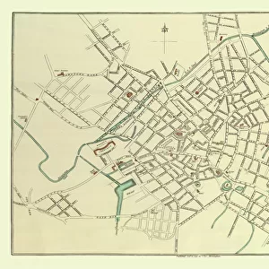
Photographic Print : Old Map of Leicester 1903


![]()
Photo Prints from MapSeeker
Old Map of Leicester 1903
J105
Welcome to the Mapseeker Image library and enter an historic gateway to one of the largest on-line collections of Historic Maps, Nostalgic Views, Vista's and Panorama's from a World gone by.
Media ID 20347180
Historic Map Old Town Plan Leicester Leicester City
15"x10" (37.5x25cm) Poster
High-quality poster prints are available in a range of sizes and are printed on 270 gsm semi-glossy silk finish poster paper. An affordable option for decorating any space, they are perfect for fixing straight onto walls. To ensure your poster arrives in good condition, we roll and send them in strong mailing tubes.
Our Photo Prints are in a large range of sizes and are printed on Archival Quality Paper for excellent colour reproduction and longevity. They are ideal for framing (our Framed Prints use these) at a reasonable cost. Alternatives include cheaper Poster Prints and higher quality Fine Art Paper, the choice of which is largely dependant on your budget.
Estimated Product Size is 37.5cm x 25cm (14.8" x 9.8")
These are individually made so all sizes are approximate
Artwork printed orientated as per the preview above, with landscape (horizontal) or portrait (vertical) orientation to match the source image.
FEATURES IN THESE COLLECTIONS
> MapSeeker
> British Town And City Plans
> English & Welsh PORTFOLIO
> Maps and Charts
> Related Images
> Sport
> Football
> Soccer
> Leicester City
EDITORS COMMENTS
This print showcases an exquisite piece of history - the Old Map of Leicester from 1903. A true treasure for map enthusiasts and history buffs alike, this vintage depiction offers a fascinating glimpse into the past. With intricate details and meticulous craftsmanship, it presents a comprehensive town plan of Leicester, capturing the essence of this vibrant city in its bygone era. As we delve into this historic map, we are transported back to a time when Leicester was still evolving and shaping its identity. The streets come alive with their original names, revealing the rich tapestry of cultural heritage that has shaped this city over centuries. From bustling market squares to charming neighborhoods, every corner tells a story waiting to be discovered. The Old Map of Leicester not only serves as a visual delight but also provides invaluable insights into urban planning and development during that period. It allows us to trace the evolution of infrastructure and landmarks that have stood the test of time or transformed beyond recognition. Whether you are an avid collector seeking rare artifacts or simply intrigued by local history, this remarkable print is sure to captivate your imagination. Let it transport you through time as you explore the intricacies woven within each street and building on this beautifully preserved old town plan.
MADE IN AUSTRALIA
Safe Shipping with 30 Day Money Back Guarantee
FREE PERSONALISATION*
We are proud to offer a range of customisation features including Personalised Captions, Color Filters and Picture Zoom Tools
SECURE PAYMENTS
We happily accept a wide range of payment options so you can pay for the things you need in the way that is most convenient for you
* Options may vary by product and licensing agreement. Zoomed Pictures can be adjusted in the Cart.