Poster Print > North America > United States of America > New York > New York > Maps
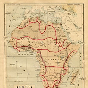
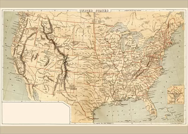
Poster Print : Map of United States 1869


![]()
Poster Prints from Fine Art Storehouse
Map of United States 1869
Cornells Grammars-School Geography - S.S. Cornell - New York D. Appleton and Company 1869
Unleash your creativity and transform your space into a visual masterpiece!
THEPALMER
Media ID 13668815
© Roberto A Sanchez
Atlantic Ocean Background Backgrounds Direction Grunge Grunge Image Technique North America Sepia Toned Obsolete
A4 (29.7 x 21cm) Poster Print
"Step back in time with our vintage Map of the United States 1869 from THEPALMER's collection at Media Storehouse. This beautiful poster print is taken from Cornell's Grammars-School Geography published by D. Appleton and Company in New York in 1869. Add an authentic touch to your home or office decor with this intricately detailed map, showcasing the historical geography of the United States during a pivotal period in its history. Bring the past to life with this timeless piece from our Fine Art Storehouse."
Premium quality poster prints are printed on luxurious semi-gloss satin 270 gsm paper. Our meticulously crafted poster prints offer an affordable option for decorating any space, making them ideal for living rooms, bedrooms, offices and beyond. To ensure your poster arrives in good condition, we roll and send them in strong mailing tubes.
Poster prints are budget friendly enlarged prints in standard poster paper sizes (A0, A1, A2, A3 etc). Whilst poster paper is sometimes thinner and less durable than our other paper types, they are still ok for framing and should last many years. Our Archival Quality Photo Prints and Fine Art Paper Prints are printed on higher quality paper and the choice of which largely depends on your budget.
Estimated Image Size (if not cropped) is 30.3cm x 19.1cm (11.9" x 7.5")
Estimated Product Size is 30.3cm x 21.6cm (11.9" x 8.5")
These are individually made so all sizes are approximate
Artwork printed orientated as per the preview above, with landscape (horizontal) orientation to match the source image.
FEATURES IN THESE COLLECTIONS
> Fine Art Storehouse
> The Magical World of Illustration
> Palmer Illustrated Collection
> Fine Art Storehouse
> Map
> Historical Maps
> Fine Art Storehouse
> Map
> USA Maps
> Arts
> Artists
> O
> Oceanic Oceanic
> Maps and Charts
> Related Images
> North America
> Related Images
> North America
> United States of America
> Maps
> North America
> United States of America
> New York
> New York
> Maps
> North America
> United States of America
> New York
> Related Images
EDITORS COMMENTS
This print showcases a remarkable piece of history, the "Map of United States 1869". A relic from the past, this map was originally featured in Cornells Grammars-School Geography - S. S. Cornell, published by D. Appleton and Company in New York back in 1869. The engraving technique used to create this cartographic masterpiece gives it an air of authenticity and adds to its allure. The sepia-toned image transports us back to a time when physical geography played a crucial role in understanding our world. With intricate details and precise markings, this map offers a glimpse into the United States as it stood over 150 years ago. From the vast Atlantic Ocean on one side to the sprawling landscapes of North America on the other, every inch is meticulously illustrated. The grunge effect applied to this horizontal background enhances its vintage charm while adding depth and character. As we gaze upon this aged treasure, we can't help but appreciate how far we've come since then. "The Map of United States 1869" by THEPALMER serves as both a visual delight and an educational tool for those curious about our nation's past. Its presence evokes nostalgia for simpler times while reminding us that progress is inevitable. Whether displayed in homes or offices, this print is sure to spark conversations about history, exploration, and the ever-changing landscape that shapes our lives today.
MADE IN AUSTRALIA
Safe Shipping with 30 Day Money Back Guarantee
FREE PERSONALISATION*
We are proud to offer a range of customisation features including Personalised Captions, Color Filters and Picture Zoom Tools
SECURE PAYMENTS
We happily accept a wide range of payment options so you can pay for the things you need in the way that is most convenient for you
* Options may vary by product and licensing agreement. Zoomed Pictures can be adjusted in the Cart.