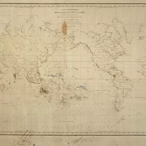
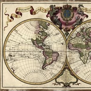
Poster Print : 1700, Cellarius Map of Asia, Europe and Africa according to Strabo, topography, cartography


![]()
Poster Prints from Liszt Collection
1700, Cellarius Map of Asia, Europe and Africa according to Strabo, topography, cartography
1700, Cellarius Map of Asia, Europe and Africa according to Strabo
Liszt Collection of nineteenth-century engravings and images to browse and enjoy
Media ID 14004471
© Artokoloro Quint Lox Limited
1700 Antique Map Latitude Longitude Mappa Mundi Old Antique Plan Old Antique View Ols Antique Map Rare Old Maps Topo
A4 (29.7 x 21cm) Poster Print
Discover the rich history of geography with our exquisite poster print from Media Storehouse's collection. Feast your eyes on the intricate detail of the 1700 Cellarius Map of Asia, Europe, and Africa, as depicted in the renowned Liszt Collection. This stunning representation of the world as known to the ancient Greek geographer Strabo, showcases the topography and cartography of the time. A captivating addition to any home or office, this poster print is a testament to the beauty of historical cartography and the fascinating evolution of our understanding of the world.
Premium quality poster prints are printed on luxurious semi-gloss satin 270 gsm paper. Our meticulously crafted poster prints offer an affordable option for decorating any space, making them ideal for living rooms, bedrooms, offices and beyond. To ensure your poster arrives in good condition, we roll and send them in strong mailing tubes.
Poster prints are budget friendly enlarged prints in standard poster paper sizes (A0, A1, A2, A3 etc). Whilst poster paper is sometimes thinner and less durable than our other paper types, they are still ok for framing and should last many years. Our Archival Quality Photo Prints and Fine Art Paper Prints are printed on higher quality paper and the choice of which largely depends on your budget.
Estimated Product Size is 30.3cm x 21.6cm (11.9" x 8.5")
These are individually made so all sizes are approximate
Artwork printed orientated as per the preview above, with landscape (horizontal) or portrait (vertical) orientation to match the source image.
EDITORS COMMENTS
This print showcases the exquisite "1700, Cellarius Map of Asia, Europe and Africa according to Strabo". A true masterpiece in topography and cartography, this vintage map takes us on a journey through time and space. With its intricate details and precise measurements, it offers a glimpse into the geographical knowledge of the past. The illustration is beautifully rendered on aged paper, giving it an authentic historical charm. Its decorative elements add to its allure as a rare antique map that holds immense value for collectors and history enthusiasts alike. The carefully plotted grid lines represent latitude and longitude, allowing viewers to navigate through different regions with ease. As we explore this ancient world depicted on the map's surface, we are reminded of the significant discoveries made by early explorers who ventured into unknown territories. This artwork serves as a window into our collective human curiosity about distant lands and cultures. With its rich colors and artistic flair, this Cellarius Map not only provides valuable geographic information but also doubles as an art piece worthy of admiration. It stands as a testament to mankind's relentless pursuit of knowledge throughout history. Whether displayed in homes or educational institutions, this remarkable print invites viewers to embark on their own historical journey while appreciating the beauty inherent in both cartography and artistry.
MADE IN AUSTRALIA
Safe Shipping with 30 Day Money Back Guarantee
FREE PERSONALISATION*
We are proud to offer a range of customisation features including Personalised Captions, Color Filters and Picture Zoom Tools
SECURE PAYMENTS
We happily accept a wide range of payment options so you can pay for the things you need in the way that is most convenient for you
* Options may vary by product and licensing agreement. Zoomed Pictures can be adjusted in the Cart.