Poster Print > Europe > Italy > Lazio > Rome
Poster Print : Anglo-Saxon 10th century world map


![]()
Poster Prints from Science Photo Library
Anglo-Saxon 10th century world map
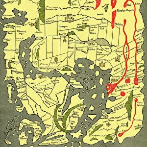
Anglo-Saxon world map, dating from the 10th century. East is top. This map of the known world was probably produced by an Irish monk. Considering the state of European learning at the time, it is an impressive geographical achievement. However, in terms of accuracy it is outclassed by maps dating from the Classical era. Important landmarks, such as Jerusalem and Rome, are marked. The original is part of the Cotton Library, held in the British Library. Taken from A Book of Discovery (1912) by M.B. Synge
Science Photo Library features Science and Medical images including photos and illustrations
Media ID 6349577
© SHEILA TERRY/SCIENCE PHOTO LIBRARY
10th Century 900s Cartography Chart Countries Country Irish Mediterranean Middle East Old World World Map British Library Mappa Mundi
A3 (42 x 29.7cm) Poster Print
Discover the rich history of the Anglo-Saxon world with our stunning poster prints from Media Storehouse. Featuring an authentic reproduction of an Anglo-Saxon 10th-century world map, this captivating print brings the mysteries of the past right into your home or office. Originally created by an Irish monk, this rare map provides a fascinating glimpse into the known world during the Anglo-Saxon era. With intricate detail and vibrant colors, this poster print is a must-have for history enthusiasts, educators, or anyone with a curiosity for the ancient world. Bring the history of the Anglo-Saxon era to life with our high-quality poster prints. Order yours today and immerse yourself in the wonders of the past.
Premium quality poster prints are printed on luxurious semi-gloss satin 270 gsm paper. Our meticulously crafted poster prints offer an affordable option for decorating any space, making them ideal for living rooms, bedrooms, offices and beyond. To ensure your poster arrives in good condition, we roll and send them in strong mailing tubes.
Poster prints are budget friendly enlarged prints in standard poster paper sizes (A0, A1, A2, A3 etc). Whilst poster paper is sometimes thinner and less durable than our other paper types, they are still ok for framing and should last many years. Our Archival Quality Photo Prints and Fine Art Paper Prints are printed on higher quality paper and the choice of which largely depends on your budget.
Estimated Product Size is 30.6cm x 42.6cm (12" x 16.8")
These are individually made so all sizes are approximate
Artwork printed orientated as per the preview above, with portrait (vertical) orientation to match the source image.
FEATURES IN THESE COLLECTIONS
> Asia
> East Timor
> Maps
> Asia
> East Timor
> Related Images
> Europe
> Italy
> Lazio
> Rome
> Europe
> Republic of Ireland
> Maps
> Historic
> Monuments and landmarks
> Maps and Charts
> Early Maps
> Maps and Charts
> Popular Maps
> Maps and Charts
> Related Images
> Maps and Charts
> World
> Posters
> Scientific Posters
EDITORS COMMENTS
This print showcases an extraordinary piece of history - the Anglo-Saxon 10th century world map. With its unique orientation, where east is placed at the top, this remarkable creation was believed to be crafted by a skilled Irish monk. Considering the limited knowledge and resources available during that era, this map stands as a testament to their impressive geographical achievement. While it may not match the accuracy of maps from the Classical era, this ancient artwork still holds immense value. It features significant landmarks like Jerusalem and Rome, providing insights into how these places were perceived in the 10th century. The original resides within the renowned Cotton Library at the British Library, adding to its historical significance. Transporting us back in time to an age when cartography was still developing, this illustration offers a glimpse into our ancestors' understanding of their world. From Europe to the Middle East and beyond, it presents a snapshot of known countries and regions during that period. As we explore this mesmerizing mappa mundi (world map), we can't help but appreciate both its artistic beauty and historical importance. Preserved through centuries in books like "A Book of Discovery" by M. B Synge (1912), it continues to fascinate scholars and enthusiasts alike with its portrayal of an old world long gone by.
MADE IN AUSTRALIA
Safe Shipping with 30 Day Money Back Guarantee
FREE PERSONALISATION*
We are proud to offer a range of customisation features including Personalised Captions, Color Filters and Picture Zoom Tools
SECURE PAYMENTS
We happily accept a wide range of payment options so you can pay for the things you need in the way that is most convenient for you
* Options may vary by product and licensing agreement. Zoomed Pictures can be adjusted in the Cart.