Poster Print : Strabos map from 18 AD


![]()
Poster Prints from Science Photo Library
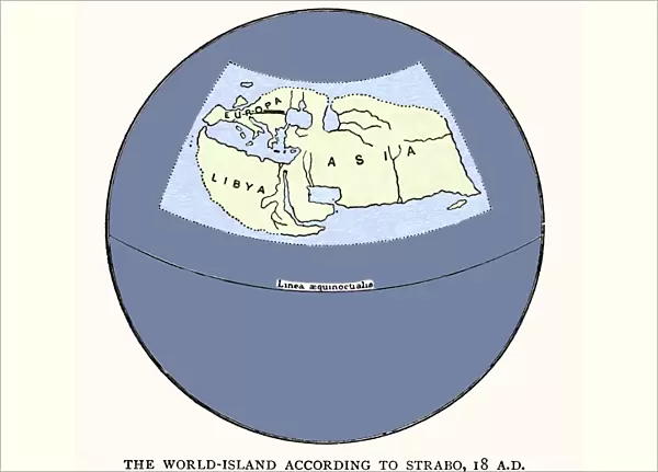
Strabos map from 18 AD
Strabos map by Strabo in 18 AD. Reconstruction of the map produced by the Greek philosopher Strabo. One of the first mapmakers to use systematic techniques to provide precision, Strabo drew on knowledge gained from the Roman great census and from conquered lands, and expanded upon the cartographic principles set out in the Hellenistic Age. He used the previous work of Eristophenes (c194 BC) to place the known world in the upper hemisphere of a spherical Earth, and used scientific reasoning to make inferences about unsurveyed areas. The original map has been lost, but Strabos writing survives
Science Photo Library features Science and Medical images including photos and illustrations
Media ID 6349907
© SHEILA TERRY/SCIENCE PHOTO LIBRARY
Antiquity Cartography Classical Exploration Globe Greek Mediterranean Roman Survey World Historic Map Strabo
A3 (42 x 29.7cm) Poster Print
Discover the historical significance of ancient cartography with our Media Storehouse Poster Prints featuring the Strabo Map from 18 AD. This captivating reproduction showcases a reconstruction of the original map produced by the renowned Greek philosopher and geographer, Strabo. Dating back to 18 AD, this map is considered one of the earliest to employ systematic techniques for enhanced precision. Bring a piece of history into your home or office with our high-quality, vibrant poster prints, perfect for education, research, or simply appreciating the beauty of ancient cartography.
Premium quality poster prints are printed on luxurious semi-gloss satin 270 gsm paper. Our meticulously crafted poster prints offer an affordable option for decorating any space, making them ideal for living rooms, bedrooms, offices and beyond. To ensure your poster arrives in good condition, we roll and send them in strong mailing tubes.
Poster prints are budget friendly enlarged prints in standard poster paper sizes (A0, A1, A2, A3 etc). Whilst poster paper is sometimes thinner and less durable than our other paper types, they are still ok for framing and should last many years. Our Archival Quality Photo Prints and Fine Art Paper Prints are printed on higher quality paper and the choice of which largely depends on your budget.
Estimated Product Size is 42.6cm x 30.6cm (16.8" x 12")
These are individually made so all sizes are approximate
Artwork printed orientated as per the preview above, with landscape (horizontal) orientation to match the source image.
EDITORS COMMENTS
This print showcases Strabo's map from 18 AD, a remarkable reconstruction of the original work by the Greek philosopher himself. Strabo was one of the pioneering mapmakers who employed systematic techniques to achieve unprecedented precision in cartography during his time. Drawing upon knowledge acquired from the Roman great census and conquered lands, he expanded upon the cartographic principles established in the Hellenistic Age. Strabo ingeniously utilized Eristophenes' earlier work to position the known world within the upper hemisphere of a spherical Earth, demonstrating his scientific reasoning abilities. Furthermore, he skillfully made educated guesses about unsurveyed areas using deductive methods. Although we have lost sight of Strabo's original map over time, fortunately, his writings have survived through centuries. This historical artifact holds immense significance as it sheds light on classical geography and offers insights into both Roman and Greek antiquity. It symbolizes an era when exploration and surveying were crucial for expanding our understanding of our planet's diverse landscapes. The image captures not only a piece of history but also exemplifies Strabo's contributions to early cartography. With its depiction of ancient civilizations around the Mediterranean region, this photograph invites us to embark on a journey back in time while appreciating how far we have come in mapping our world accurately.
MADE IN AUSTRALIA
Safe Shipping with 30 Day Money Back Guarantee
FREE PERSONALISATION*
We are proud to offer a range of customisation features including Personalised Captions, Color Filters and Picture Zoom Tools
SECURE PAYMENTS
We happily accept a wide range of payment options so you can pay for the things you need in the way that is most convenient for you
* Options may vary by product and licensing agreement. Zoomed Pictures can be adjusted in the Cart.