16th Century Galleon

![]()
Wall Art and Photo Gifts from Science Photo Library
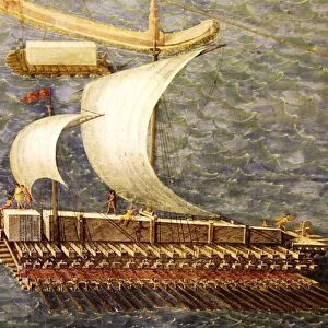
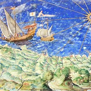
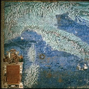
16th Century Galleon
16th century galleon in the Gulf of Porto. Detail from a map of Corsica in the Gallery of Maps in the Vatican Museum. These maps were commissioned between 1578 and 1580 to show the regions of Italy and territories of the church. They are based on the work of Ignazio Danti, a 16th century Italian priest, mathematician, astronomer and cosmographer, and are an important record of 16th century geography
Science Photo Library features Science and Medical images including photos and illustrations
Media ID 6319795
© Sheila Terry
1500s 16th Century Corsica Gallery Of Maps Ignazio Danti Italy Mapping Maps Nautical Sciences Sixteenth Century Galleon Sea Faring
EDITORS COMMENTS
This print showcases a remarkable 16th-century galleon sailing gracefully in the Gulf of Porto, as depicted on a map of Corsica. Found within the prestigious Gallery of Maps at the Vatican Museum, this detailed illustration forms part of a series commissioned between 1578 and 1580 to portray Italy's regions and the Church's territories. The mastermind behind these invaluable maps was none other than Ignazio Danti, an accomplished Italian priest, mathematician, astronomer, and cosmographer. Serving as an essential historical record of 16th-century geography, Danti's work highlights his profound understanding of nautical exploration during this era. Transporting us back in time to the vibrant maritime history of Italy, this image evokes images of intrepid sea-farers embarking on perilous voyages across uncharted waters. The grandeur and elegance exuded by this majestic galleon symbolize both technological advancements and artistic prowess prevalent during the Renaissance period. As we delve into this visual masterpiece from Science Photo Library's collection, it becomes evident that mapping sciences played a pivotal role in documenting our world's evolution. This particular print not only celebrates Italy’s rich heritage but also pays homage to Ignazio Danti’s immense contributions to cartography. With its intricate details capturing every aspect of life at sea during the 1500s – from towering masts adorned with billowing sails to meticulously designed hulls – this photograph serves as a testament to human curiosity and exploration throughout history.
MADE IN AUSTRALIA
Safe Shipping with 30 Day Money Back Guarantee
FREE PERSONALISATION*
We are proud to offer a range of customisation features including Personalised Captions, Color Filters and Picture Zoom Tools
SECURE PAYMENTS
We happily accept a wide range of payment options so you can pay for the things you need in the way that is most convenient for you
* Options may vary by product and licensing agreement. Zoomed Pictures can be adjusted in the Cart.