Home > Europe > France > Canton > Landes
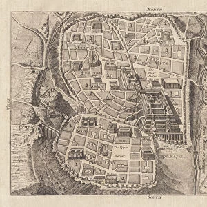
1702 Visscher Stoopendaal Map Of Israel Palestine Or The Holy Land

![]()
Wall Art and Photo Gifts from Universal Images Group (UIG)
1702 Visscher Stoopendaal Map Of Israel Palestine Or The Holy Land
1702, Visscher Stoopendaal Map of Israel, Palestine or the Holy Land
Universal Images Group (UIG) manages distribution for many leading specialist agencies worldwide
Media ID 38547817
© Artokoloro Quint Lox Limited
1702 Antique Map Latitude Longitude Mappa Mundi Old Antique Plan Old Antique View Ols Antique Map Rare Old Maps Topo
FEATURES IN THESE COLLECTIONS
> Asia
> Israel
> Related Images
> Asia
> Palestine
> Related Images
> Europe
> France
> Canton
> Landes
> Historic
> Space exploration
> Maps and Charts
> Early Maps
> Maps and Charts
> Related Images
> Maps and Charts
> World
> Universal Images Group (UIG)
> History
> Historical Maps
EDITORS COMMENTS
Step back in time to the early 18th century with this stunning print of the Visscher Stoopendaal Map of Israel, Palestine or the Holy Land (1702). This exquisite illustration is a testament to the cartographic skills of its creator, showcasing the region's intricate topography and geography. The map is a masterpiece of geometric precision, featuring detailed illustrations of cities, towns, and landmarks alongside precise measurements and coordinates.
The Visscher Stoopendaal Map is a rare and valuable piece of historical documentation, offering a glimpse into the world as it was over three centuries ago. It's a fascinating window into the past, providing insight into how our understanding of this ancient region has evolved over time.
This beautiful print would make a unique addition to any room or office, serving as a conversation starter for anyone interested in history, geography, or art. Its vintage charm and aged appearance add an air of nostalgia and sophistication to any space.
Whether you're an historian, collector, or simply someone who appreciates beauty and craftsmanship, this incredible map print is sure to captivate your senses. So why not take a journey through time with us? Let this stunning piece transport you back to an era when exploration was at its peak.
MADE IN AUSTRALIA
Safe Shipping with 30 Day Money Back Guarantee
FREE PERSONALISATION*
We are proud to offer a range of customisation features including Personalised Captions, Color Filters and Picture Zoom Tools
SECURE PAYMENTS
We happily accept a wide range of payment options so you can pay for the things you need in the way that is most convenient for you
* Options may vary by product and licensing agreement. Zoomed Pictures can be adjusted in the Cart.