Home > Historic > Ancient civilizations > Roman Empire > Roman art
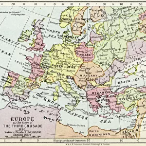
1715 De L'Isle Map Of The Eastern Roman Empire Under Constantine

![]()
Wall Art and Photo Gifts from Universal Images Group (UIG)
1715 De L'Isle Map Of The Eastern Roman Empire Under Constantine
1715, De L'Isle Map of the Eastern Roman Empire under Constantine, Asia Minor, Black Sea, Balkans
Universal Images Group (UIG) manages distribution for many leading specialist agencies worldwide
Media ID 38547823
© Artokoloro Quint Lox Limited
1715 Balkans Black Sea Antique Map Asia Minor Latitude Longitude Mappa Mundi Old Antique Plan Old Antique View Ols Antique Map Rare Old Maps Topo
FEATURES IN THESE COLLECTIONS
> Arts
> Artists
> R
> Roman Roman
> Europe
> France
> Canton
> Landes
> Historic
> Ancient civilizations
> Roman Empire
> Roman art
> Historic
> Space exploration
> Maps and Charts
> Early Maps
> Maps and Charts
> Related Images
> Maps and Charts
> World
> Universal Images Group (UIG)
> History
> Historical Maps
EDITORS COMMENTS
Step back in time to the 18th century with this stunning print of the 1715 De L'Isle Map of the Eastern Roman Empire under Constantine. This exquisite illustration, courtesy of Universal Images Group (UIG), offers a fascinating glimpse into the ancient world as it was understood during the early Enlightenment era.
The map depicts the vast expanse of Asia Minor, stretching from modern-day Turkey to Greece and Bulgaria, along with parts of Europe and Africa. The intricate details reveal a rich tapestry of geography, topography, and cartography that would have been cutting-edge for its time.
De L'Isle's masterpiece showcases his remarkable skill as a cartographer, weaving together information gathered from ancient sources such as Ptolemy's Geographia with more contemporary accounts from travelers and explorers. The result is a visually striking representation of an empire that once spanned across three continents.
This vintage map is not only a testament to human ingenuity but also serves as a window into our collective past. It invites us to explore the journeys taken by those who came before us, navigating uncharted territories and recording their discoveries on parchment or vellum.
As we gaze upon this beautiful print, we are reminded that even in an age dominated by digital mapping technology, there remains something undeniably captivating about these hand-drawn masterpieces that capture our imagination and inspire our sense of adventure.
MADE IN AUSTRALIA
Safe Shipping with 30 Day Money Back Guarantee
FREE PERSONALISATION*
We are proud to offer a range of customisation features including Personalised Captions, Color Filters and Picture Zoom Tools
SECURE PAYMENTS
We happily accept a wide range of payment options so you can pay for the things you need in the way that is most convenient for you
* Options may vary by product and licensing agreement. Zoomed Pictures can be adjusted in the Cart.