Home > Europe > France > Paris > Maps
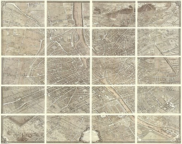
1739 Bretez Turgot View And Map Of Paris France
![]()

Wall Art and Photo Gifts from Universal Images Group (UIG)
1739 Bretez Turgot View And Map Of Paris France
1739, Bretez, Turgot View and Map of Paris, France, c. 1900
Universal Images Group (UIG) manages distribution for many leading specialist agencies worldwide
Media ID 38547901
© Artokoloro Quint Lox Limited
1739 1900 Antique Map Bretez Latitude Longitude Mappa Mundi Old Antique Plan Old Antique View Ols Antique Map Rare Old Maps Topo Turgot View And Map Of Paris
FEATURES IN THESE COLLECTIONS
> Europe
> France
> Canton
> Landes
> Europe
> France
> Paris
> Maps
> Europe
> France
> Paris
> Related Images
> Historic
> Space exploration
> Maps and Charts
> Early Maps
> Maps and Charts
> Related Images
> Maps and Charts
> World
> Universal Images Group (UIG)
> History
> Historical Maps
EDITORS COMMENTS
Step back in time to 1739 with this stunning print of the Bretez Turgot View and Map of Paris, France. This exquisite illustration is a masterpiece of cartography, showcasing the City of Light in all its Baroque glory. Created by French engraver Louis Bretez and geographer Philippe Buache de Messein, this map is a testament to the artistry and precision of 18th-century cartographers.
The intricate details on this print reveal a city teeming with life, from grand boulevards to charming alleys, ornate fountains to majestic churches. The map's geometric layout provides an insight into the urban planning and architecture of Paris during that era. Take note of the Seine River snaking its way through the heart of the city, as well as the imposing walls that once surrounded ancient Paris.
This vintage print is not only a beautiful piece of art but also a valuable historical document that offers a glimpse into Paris' rich past. It's an essential addition for anyone fascinated by geography, history, or simply admiring old maps. Whether you're an armchair traveler or an avid collector, this rare find will transport you back in time to an era when navigation was both an art and a science.
MADE IN AUSTRALIA
Safe Shipping with 30 Day Money Back Guarantee
FREE PERSONALISATION*
We are proud to offer a range of customisation features including Personalised Captions, Color Filters and Picture Zoom Tools
SECURE PAYMENTS
We happily accept a wide range of payment options so you can pay for the things you need in the way that is most convenient for you
* Options may vary by product and licensing agreement. Zoomed Pictures can be adjusted in the Cart.


