Home > Europe > United Kingdom > Scotland > Maps
1818 Pinkerton Map Of Abyssinia Ethiopia Sudan And Nubia

![]()
Wall Art and Photo Gifts from Universal Images Group (UIG)
1818 Pinkerton Map Of Abyssinia Ethiopia Sudan And Nubia
1818, Pinkerton Map of Abyssinia, Ethiopia, Sudan and Nubia, John Pinkerton, 1758 - 1826, Scottish antiquarian, cartographer, UK
Universal Images Group (UIG) manages distribution for many leading specialist agencies worldwide
Media ID 38548409
© Artokoloro Quint Lox Limited
1758 – 1826 1818 Cartographer Ethiopia John Pinkerton Scottish Antiquarian Antique Map Latitude Longitude Mappa Mundi Old Antique Plan Old Antique View Ols Antique Map Rare Old Maps Topo
FEATURES IN THESE COLLECTIONS
> Africa
> Ethiopia (Abyssinia)
> Maps
> Africa
> Ethiopia (Abyssinia)
> Related Images
> Africa
> Ethiopia
> Related Images
> Africa
> Sudan
> Related Images
> Europe
> France
> Canton
> Landes
> Europe
> United Kingdom
> Maps
> Europe
> United Kingdom
> Scotland
> Maps
> Historic
> Space exploration
> Maps and Charts
> Early Maps
> Universal Images Group (UIG)
> History
> Historical Maps
EDITORS COMMENTS
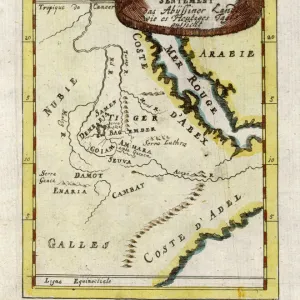
Step back in time to the early 19th century with this stunning print of John Pinkerton's 1818 map of Abyssinia, Ethiopia, Sudan, and Nubia. This beautifully rendered illustration is a testament to the cartographer's skill and attention to detail. The intricate design features lush green forests, vast deserts, and winding rivers that crisscross the region.
Pinkerton's map provides a fascinating glimpse into the geography of this ancient land, which was largely unknown to Europeans at the time. The map shows the kingdoms of Abyssinia and Nubia, as well as the territories controlled by Egypt and Turkey. It also highlights key trade routes and cities along the Nile River.
This vintage print is not only a beautiful piece of art but also a significant historical artifact that offers insight into our understanding of these regions during this period. It would make a unique addition to any collection or room decor for anyone interested in history, geography, or travel.
MADE IN AUSTRALIA
Safe Shipping with 30 Day Money Back Guarantee
FREE PERSONALISATION*
We are proud to offer a range of customisation features including Personalised Captions, Color Filters and Picture Zoom Tools
SECURE PAYMENTS
We happily accept a wide range of payment options so you can pay for the things you need in the way that is most convenient for you
* Options may vary by product and licensing agreement. Zoomed Pictures can be adjusted in the Cart.