Home > Europe > France > Canton > Landes
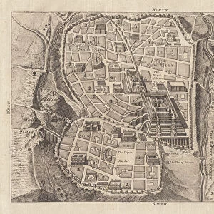
1827 Finley Map Of Turkey In Asia Iraq And Israel

![]()
Wall Art and Photo Gifts from Universal Images Group (UIG)
1827 Finley Map Of Turkey In Asia Iraq And Israel
1827, Finley Map of Turkey in Asia, Iraq and Israel, Palestine, Anthony Finley mapmaker of the United States in the 19th century
Universal Images Group (UIG) manages distribution for many leading specialist agencies worldwide
Media ID 38548495
© Artokoloro Quint Lox Limited
1827 Palestine Antique Map Latitude Longitude Mappa Mundi Old Antique Plan Old Antique View Ols Antique Map Rare Old Maps Topo
FEATURES IN THESE COLLECTIONS
> Asia
> Iraq
> Related Images
> Asia
> Israel
> Related Images
> Asia
> Palestine
> Related Images
> Asia
> Turkey
> Related Images
> Europe
> France
> Canton
> Landes
> Historic
> Space exploration
> Maps and Charts
> Early Maps
> Universal Images Group (UIG)
> History
> Historical Maps
EDITORS COMMENTS
Step back in time to the early 19th century with this stunning print of Anthony Finley's 1827 map of Turkey in Asia, Iraq, and Israel. This beautifully illustrated chart showcases the geographical boundaries and topography of the region during a pivotal moment in history. Finley, an American cartographer, has meticulously mapped out the landmasses, rivers, and cities with precision and accuracy.
The intricate details on this vintage map reveal a fascinating glimpse into the past. From the ancient city of Baghdad to the holy lands of Jerusalem and Bethlehem, every feature is carefully rendered in exquisite detail. The map also highlights trade routes, mountain ranges, and deserts that have shaped human migration patterns throughout history.
This rare antique print is not only a testament to Finley's skill as a cartographer but also a window into the world before modern technology transformed our understanding of geography. It serves as a reminder that even as we continue to explore new frontiers today, there is still so much to learn from our historical maps about human settlement patterns, cultural exchange networks, and environmental influences on society.
Hang this beautiful piece on your wall or frame it for display - it makes for an unforgettable conversation starter!
MADE IN AUSTRALIA
Safe Shipping with 30 Day Money Back Guarantee
FREE PERSONALISATION*
We are proud to offer a range of customisation features including Personalised Captions, Color Filters and Picture Zoom Tools
SECURE PAYMENTS
We happily accept a wide range of payment options so you can pay for the things you need in the way that is most convenient for you
* Options may vary by product and licensing agreement. Zoomed Pictures can be adjusted in the Cart.