Home > Europe > France > Canton > Landes
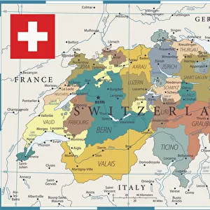
1862 Stieler Map Of Southern Germany And Switzerland

![]()
Wall Art and Photo Gifts from Universal Images Group (UIG)
1862 Stieler Map Of Southern Germany And Switzerland
1862, Stieler Map of Southern Germany and Switzerland
Universal Images Group (UIG) manages distribution for many leading specialist agencies worldwide
Media ID 38551582
© Artokoloro Quint Lox Limited
1862 Antique Map Latitude Longitude Mappa Mundi Old Antique Plan Old Antique View Ols Antique Map Rare Old Maps Topo
FEATURES IN THESE COLLECTIONS
> Europe
> France
> Canton
> Landes
> Europe
> Switzerland
> Maps
> Europe
> Switzerland
> Related Images
> Historic
> Space exploration
> Maps and Charts
> Early Maps
> Maps and Charts
> Related Images
> Maps and Charts
> Switzerland
> Maps and Charts
> World
> Universal Images Group (UIG)
> History
> Historical Maps
EDITORS COMMENTS
Step back in time and explore the breathtaking topography of Southern Germany and Switzerland with this stunning 1862 Stieler Map. This vintage print is a masterpiece of cartography, showcasing the region's intricate network of mountains, rivers, and valleys in exquisite detail.
The map was created by August Heinrich Petermann Stieler, a renowned German cartographer who was known for his meticulous attention to detail and innovative techniques. The result is a work of art that not only provides valuable geographic information but also serves as a testament to the era's artistic style.
As you gaze upon this aged paper, you can almost hear the whispers of history - imagine the countless travelers who used this very map to navigate through these picturesque landscapes. From the snow-capped peaks of the Alps to the rolling hills of Bavaria, every contour line tells a story of exploration and discovery.
This rare old map is more than just a piece of geography; it's an invitation to embark on a journey through time. Let its ancient lines guide you through winding roads, bustling cities, and serene countryside as you uncover hidden secrets and marvel at humanity's enduring fascination with mapping our world.
MADE IN AUSTRALIA
Safe Shipping with 30 Day Money Back Guarantee
FREE PERSONALISATION*
We are proud to offer a range of customisation features including Personalised Captions, Color Filters and Picture Zoom Tools
SECURE PAYMENTS
We happily accept a wide range of payment options so you can pay for the things you need in the way that is most convenient for you
* Options may vary by product and licensing agreement. Zoomed Pictures can be adjusted in the Cart.