Home > Europe > France > Canton > Landes
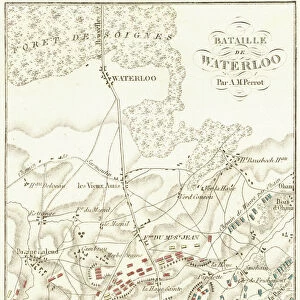
1866 Johnson Map Of Holland And Belgium Topography

![]()
Wall Art and Photo Gifts from Universal Images Group (UIG)
1866 Johnson Map Of Holland And Belgium Topography
1866, Johnson Map of Holland and Belgium
Universal Images Group (UIG) manages distribution for many leading specialist agencies worldwide
Media ID 38551822
© Artokoloro Quint Lox Limited
1866 Antique Map Latitude Longitude Mappa Mundi Old Antique Plan Old Antique View Ols Antique Map Rare Old Maps Topo
FEATURES IN THESE COLLECTIONS
> Europe
> Belgium
> Related Images
> Europe
> France
> Canton
> Landes
> Historic
> Space exploration
> Maps and Charts
> Early Maps
> Maps and Charts
> Related Images
> Maps and Charts
> World
> Universal Images Group (UIG)
> History
> Historical Maps
EDITORS COMMENTS
Step into the past with this stunning 1866 Johnson Map of Holland and Belgium Topography, a beautifully rendered illustration that showcases the intricate geography of these European countries. This vintage map is a treasure trove of historical cartography, offering a fascinating glimpse into the region's topographical features, cities, and towns.
The map's intricate details include mountains, rivers, lakes, and coastlines, all meticulously drawn to provide an accurate representation of the landscape. The surrounding borders are adorned with decorative flourishes and subtle shading, adding an air of elegance to this already impressive piece.
This historic map is not only a beautiful work of art but also a valuable resource for anyone interested in geography, travel, or history. It would make a unique addition to any collection or office decor. Whether you're an armchair traveler or simply appreciate the beauty of old maps, this print is sure to captivate your imagination.
Take a journey through time and explore the rich cultural heritage of Holland and Belgium as seen through the eyes of 19th-century cartographers. This exquisite print is sure to delight historians, geographers, and anyone who appreciates the beauty of vintage maps.
MADE IN AUSTRALIA
Safe Shipping with 30 Day Money Back Guarantee
FREE PERSONALISATION*
We are proud to offer a range of customisation features including Personalised Captions, Color Filters and Picture Zoom Tools
SECURE PAYMENTS
We happily accept a wide range of payment options so you can pay for the things you need in the way that is most convenient for you
* Options may vary by product and licensing agreement. Zoomed Pictures can be adjusted in the Cart.