Canvas Print > Arts > Artists > O > Oceanic Oceanic
Canvas Print : map of the world 1867


![]()
Canvas Prints from Fine Art Storehouse
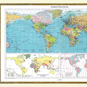
map of the world 1867
meteorological map of the world 1867 - showing isothermal lines
Unleash your creativity and transform your space into a visual masterpiece!
THEPALMER
Media ID 21177703
© THEPALMER
Atlas Australia Backgrounds Earth Grunge North America Oceania Pacific Ocean Paper Patina Retro Revival Sending South America Stained Temperature Textured Effect The Americas World Map
20"x16" (51x41cm) Canvas Print
Discover the captivating allure of the past with our Media Storehouse Canvas Print of the Meteorological Map of the World, 1867 by THEPALMER from Fine Art Storehouse. This exquisite piece of historical art showcases a meticulously detailed map depicting isothermal lines from a bygone era. With its intriguing representation of weather patterns from over a century ago, this canvas print adds an enchanting touch to any room, transporting you back in time. Embrace the beauty of history and enhance your home decor with this unique and captivating work of art.
Delivered stretched and ready to hang our premium quality canvas prints are made from a polyester/cotton blend canvas and stretched over a 1.25" (32mm) kiln dried knot free wood stretcher bar. Packaged in a plastic bag and secured to a cardboard insert for safe transit.
Canvas Prints add colour, depth and texture to any space. Professionally Stretched Canvas over a hidden Wooden Box Frame and Ready to Hang
Estimated Product Size is 50.8cm x 40.6cm (20" x 16")
These are individually made so all sizes are approximate
Artwork printed orientated as per the preview above, with landscape (horizontal) orientation to match the source image.
FEATURES IN THESE COLLECTIONS
> Africa
> Related Images
> Africa
> South Africa
> Lakes
> Related Images
> Africa
> South Africa
> Maps
> Africa
> South Africa
> Related Images
> Arts
> Artists
> O
> Oceanic Oceanic
> Europe
> Related Images
> Maps and Charts
> Related Images
> Fine Art Storehouse
> Map
> Historical Maps
EDITORS COMMENTS
This print titled "Map of the World 1867" takes us on a journey back in time to explore the intricate details of an antique meteorological map. The image showcases isothermal lines, which beautifully depict temperature variations across different regions. The retro revival aesthetic adds a touch of nostalgia and charm to this piece. The artistry of cartography shines through as we observe the carefully drawn continents, including Europe, Africa, North America, South America, Australia, and Oceania. Each landmass is intricately textured with a stained effect that gives it an old-fashioned appeal. As our eyes wander across the vast expanse of this world map, we can't help but marvel at how physical geography was represented during that era. The background's grunge patina further enhances the vintage feel and transports us to a bygone era when maps were meticulously crafted on paper. This particular print captures not only Earth's diverse landscapes but also highlights bodies of water like the Pacific Ocean and various lakes. "The Map of the World 1867" by THEPALMER invites us to embark on an imaginary voyage around our planet while appreciating its historical significance. It serves as a reminder of humanity's enduring fascination with exploration and discovery throughout history. Whether displayed in homes or offices, this artwork will undoubtedly spark conversations about travel and geography for all who encounter it.
MADE IN AUSTRALIA
Safe Shipping with 30 Day Money Back Guarantee
FREE PERSONALISATION*
We are proud to offer a range of customisation features including Personalised Captions, Color Filters and Picture Zoom Tools
SECURE PAYMENTS
We happily accept a wide range of payment options so you can pay for the things you need in the way that is most convenient for you
* Options may vary by product and licensing agreement. Zoomed Pictures can be adjusted in the Cart.