Cushion > Europe > United Kingdom > England > London > Royalty
Cushion : Physical Map of the Ottoman Empire, c1915. Creator: Unknown


![]()
Home Decor from Heritage Images
Physical Map of the Ottoman Empire, c1915. Creator: Unknown
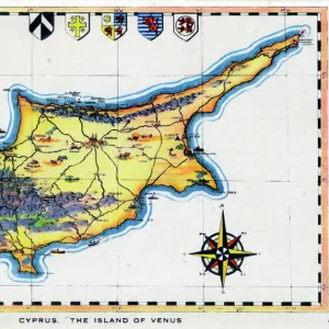
Physical Map of the Ottoman Empire, c1915. Map showing the eastern Mediterranean, Cyprus, the Middle East, the rivers Tigris and Euphrates, what is now Turkey, and part of Egypt. Also shown are the Royal Road, trade routes, mountain ranges and deserts. From " The Caliphs Last Heritage, a short history of the Turkish Empire" by Lt.-Col. Sir Mark Sykes. [Macmillan & Co, London, 1915]
Heritage Images features heritage image collections
Media ID 19658845
© The Print Collector/Heritage Images
6th Baronet Colonel Sir Tatton Benvenuto Mark Sykes Desert Euphrates Lieutenant Colonel Sir Mark Sykes Macmillan Macmillan And Co Macmillan Publishers Macmillan Publishers Ltd Mark Mark Sykes Mediterranean Sea Mountain Range Nile Nile Delta Ottoman Empire Publishers Macmillan River Euphrates River Nile River Tigris Sir Mark Sykes Sykes Sykes Mark Sykes Mark Sir Sykes Tatton Benvenuto Mark Tatton Benvenuto Mark Tatton Benvenuto Mark Sykes The Nile Tigris Tigris River Turkey Turkish Mizraim
Cushion
Refresh your home decor with a beautiful full photo 16"x16" (40x40cm) cushion, complete with cushion pad insert. Printed on both sides and made from 100% polyester with a zipper on the bottom back edge of the cushion cover. Care Instructions: Warm machine wash, do not bleach, do not tumble dry. Warm iron inside out. Do not dry clean.
Accessorise your space with decorative, soft cushions
Estimated Product Size is 40cm x 40cm (15.7" x 15.7")
These are individually made so all sizes are approximate
Artwork printed orientated as per the preview above, with landscape (horizontal) or portrait (vertical) orientation to match the source image.
FEATURES IN THESE COLLECTIONS
> Africa
> Egypt
> Related Images
> Animals
> Mammals
> Muridae
> Desert Mouse
> Arts
> Landscape paintings
> Waterfall and river artworks
> River artworks
> Asia
> Cyprus
> Related Images
> Asia
> Related Images
> Asia
> Turkey
> Related Images
> Europe
> United Kingdom
> England
> London
> Royalty
> Maps and Charts
> Related Images
EDITORS COMMENTS
This print showcases a physical map of the Ottoman Empire, dating back to approximately 1915. Created by an unknown artist, this detailed map offers a glimpse into the geographical features and territories encompassed by the empire during that time. The map encompasses vast regions including the eastern Mediterranean, Cyprus, the Middle East, parts of Egypt, and what is now modern-day Turkey. It highlights prominent landmarks such as the rivers Tigris and Euphrates, which played significant roles in shaping ancient civilizations. Additionally, trade routes like the Royal Road are depicted alongside mountain ranges and deserts that characterized these lands. Lt. -Col. Sir Mark Sykes provides historical context to this remarkable piece through his book "The Caliphs Last Heritage: A Short History of the Turkish Empire". Published in London by Macmillan & Co in 1915, Sykes' work sheds light on various aspects of this influential empire's legacy. As we gaze upon this monochromatic image captured by The Print Collector from Heritage Images collection, we are transported back in time to an era when empires reigned supreme and borders were defined differently than they are today. This photograph serves as a testament to both human curiosity about our past and our desire to understand how geography has shaped our world throughout history.
MADE IN AUSTRALIA
Safe Shipping with 30 Day Money Back Guarantee
FREE PERSONALISATION*
We are proud to offer a range of customisation features including Personalised Captions, Color Filters and Picture Zoom Tools
SECURE PAYMENTS
We happily accept a wide range of payment options so you can pay for the things you need in the way that is most convenient for you
* Options may vary by product and licensing agreement. Zoomed Pictures can be adjusted in the Cart.