Home > Arts > Artists > B > Baptista Boazio
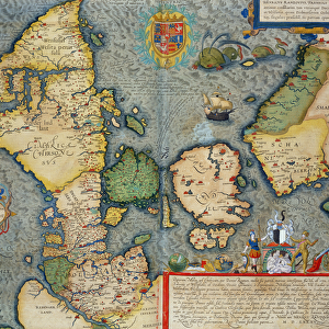
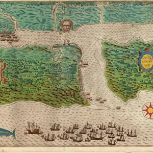
Double-page map of Northern Europe, 1575 (colour engraving)
")
![]()
Wall Art and Photo Gifts from Fine Art Finder
Double-page map of Northern Europe, 1575 (colour engraving)
985737 Double-page map of Northern Europe, 1575 (colour engraving) by Ortelius, Abraham (1527-98) (after); 42.4x29.5 (folio size) cm; Private Collection; (add.info.: Double-page map of Northern Europe. Plate from Theatrum Orbis Terrarum. After Abraham Ortelius (1527-1598). Colour engraving. Published in 1575. 42.4 x 29.5cm (folio size).); Photo eChristies Images; Flemish, out of copyright
Media ID 22202804
© Christie's Images / Bridgeman Images
1570s 1575 Abraham Ortelius Artist Belgian Belgian Art Belgian Artist Carpet Cartography Double Page Engraved Furnishing Geographic Late Sixteenth Century Latin Text Navigational Equipment Northern Ortelius Page Plate Prints Soft Furnishing Spread Theatrum Orbis Terrarum Interior Decoration Natural Space
FEATURES IN THESE COLLECTIONS
> Animals
> Mammals
> Pitheciidae
> Baptista
> Arts
> Artists
> B
> Baptista Boazio
> Arts
> Artists
> O
> Abraham Ortelius
> Europe
> Related Images
> Fine Art Finder
> Artists
> Abraham (after) Ortelius
> Fine Art Finder
> Artists
> Baptista Boazio
> Fine Art Finder
> Temp Classification
> Maps and Charts
> Abraham Ortelius
EDITORS COMMENTS
This vibrant and detailed double-page map of Northern Europe, created in 1575 by Abraham Ortelius, is a captivating piece of cartography. Measuring at 42.4x29.5cm, it showcases the artist's meticulous attention to detail and skillful engraving techniques. The map, part of Theatrum Orbis Terrarum collection, offers a glimpse into the geographical knowledge and exploration of the late sixteenth century. With its Latin text and intricate illustrations, it serves as both a navigational tool and an artistic masterpiece. The coastline is beautifully depicted with precise accuracy, allowing viewers to trace their fingers along the shorelines that stretch from one corner to another. The maritime theme is further enhanced by the inclusion of navigational equipment scattered across the page. Displayed against a backdrop of soft furnishings and décor typical of interior decoration during this period, this print adds an elegant touch to any space it graces. Its rich colors bring life to every leaf on trees dotting the landscape while showcasing European coastlines in stunning detail. As you explore this double-page map closer, you'll discover engraved plates filled with geographic information that transport you back in time. It's truly remarkable how Ortelius captured such vast knowledge within these pages without compromising on aesthetic beauty. Whether you're a history enthusiast or simply appreciate fine art prints like this one by Bridgeman Images from Fine Art Finder, this double-page map will undoubtedly captivate your imagination with its historical significance and artistic brilliance
MADE IN AUSTRALIA
Safe Shipping with 30 Day Money Back Guarantee
FREE PERSONALISATION*
We are proud to offer a range of customisation features including Personalised Captions, Color Filters and Picture Zoom Tools
SECURE PAYMENTS
We happily accept a wide range of payment options so you can pay for the things you need in the way that is most convenient for you
* Options may vary by product and licensing agreement. Zoomed Pictures can be adjusted in the Cart.