Home > Europe > United Kingdom > Scotland > Maps
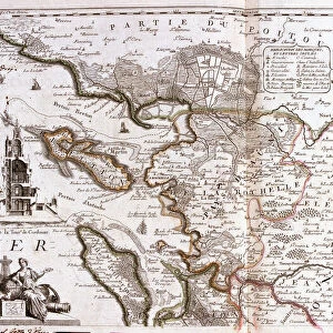
Map of Iceland and Northern British Isles, in the North Sea, 1704 (etching, 1717)
")
![]()
Wall Art and Photo Gifts from Fine Art Finder
Map of Iceland and Northern British Isles, in the North Sea, 1704 (etching, 1717)
LRI4711200 Map of Iceland and Northern British Isles, in the North Sea, 1704 (etching, 1717) by Nolin, Jean-Baptiste (c.1657-1708); Private Collection; (add.info.: Map of Iceland and Northern British Isles, in the North Sea, 1704 - Engraving from the atlas le theatre du monde, 1717, by Jean Baptiste Nolin (1686-1762) - Map of Iceland, 1704 - From " Le Theatre du Monde" 1717 by Jean-Baptiste Nolin); Luisa Ricciarini; French, out of copyright
Media ID 23329490
© Luisa Ricciarini / Bridgeman Images
Atlas Book Geographical Map Iceland Icelandic Icelandic Women
FEATURES IN THESE COLLECTIONS
> Arts
> Artists
> Related Images
> Europe
> Republic of Ireland
> Maps
> Europe
> United Kingdom
> England
> Maps
> Europe
> United Kingdom
> Scotland
> Maps
> Fine Art Finder
> Artists
> Hieronymus Fabricius ab Aquapendente
> Fine Art Finder
> Artists
> Jean-Baptiste Nolin
EDITORS COMMENTS
This print showcases a historical map titled "Map of Iceland and Northern British Isles, in the North Sea, 1704". Created by Jean-Baptiste Nolin in 1717, this etching is part of the renowned atlas le theatre du monde. The intricate details and precision of this engraving offer a glimpse into the geographical landscape of Iceland and its neighboring British Isles during the early 18th century. The map depicts Ireland, England, Scotland, and Brittany with remarkable accuracy. It provides an invaluable visual representation of the region's topography, showcasing rivers, mountains, coastlines, and cities. This comprehensive cartographic masterpiece allows us to explore the connection between these lands while highlighting their individual characteristics. Jean-Baptiste Nolin's expertise as a cartographer shines through in this artwork. His meticulous attention to detail captures not only geographical features but also cultural aspects such as Icelandic women depicted within the map itself. This inclusion adds depth to our understanding of these regions during that time period. As we admire Luisa Ricciarini's expertly captured photograph of this historic print from her private collection, we are transported back to an era where maps were essential tools for exploration and navigation. This image serves as a reminder of how art can bridge gaps between history and modernity while offering insights into past civilizations' knowledge and perspectives on geography.
MADE IN AUSTRALIA
Safe Shipping with 30 Day Money Back Guarantee
FREE PERSONALISATION*
We are proud to offer a range of customisation features including Personalised Captions, Color Filters and Picture Zoom Tools
SECURE PAYMENTS
We happily accept a wide range of payment options so you can pay for the things you need in the way that is most convenient for you
* Options may vary by product and licensing agreement. Zoomed Pictures can be adjusted in the Cart.