Home > North America > United States of America > New York > New York > Sights > New York Public Library
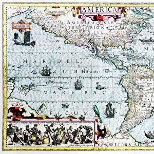
Antique map of Channel, 1666 (colour engraving)
")
![]()
Wall Art and Photo Gifts from Fine Art Finder
Antique map of Channel, 1666 (colour engraving)
5242477 Antique map of Channel, 1666 (colour engraving) by Goos, Pieter (1616-1675); New York Public Library, USA; (add.info.: Het Canaal tusschen Engeland en Vrancriick); Dutch, out of copyright
Media ID 22567264
© Bridgeman Images
Atlas Cartography Channel Compass Continent English Channel Hydrography La Manche Nautical Navigation Rhumb Lines Sea Chart
FEATURES IN THESE COLLECTIONS
> Arts
> Artists
> G
> Pieter Goos
> Arts
> Artists
> H
> Jodocus Hondius
> Europe
> France
> Canton
> Manche
> Europe
> United Kingdom
> England
> Maps
> Europe
> United Kingdom
> England
> York
> Fine Art Finder
> Artists
> Jodocus Hondius
> Fine Art Finder
> Artists
> Pieter Goos
> North America
> United States of America
> Maps
> North America
> United States of America
> New York
> New York
> Maps
> North America
> United States of America
> New York
> New York
> Sights
> New York Public Library
EDITORS COMMENTS
This antique map of the Channel, dating back to 1666, takes us on a journey through time and space. Created by Pieter Goos, a renowned Dutch cartographer of the 17th century, this colour engraving is a true masterpiece that now resides in the prestigious New York Public Library. The intricate details of this map showcase not only Goos' exceptional skill but also his deep understanding of hydrography and maritime navigation. From the beautifully illustrated coat of arms to the precise depiction of rhumb lines and compass directions, every element serves as a testament to the artistry and scientific accuracy employed in creating this work. As we explore this historic chart, we are transported to an era when sea travel was both treacherous and awe-inspiring. The English Channel comes alive with its coastal towns, including England's iconic coastline and Brittany's picturesque shores across continental Europe. This map offers valuable insights into navigation routes during that period while providing glimpses into trade routes between England and France. With its meticulous engravings capturing every contour of landmasses meeting vast oceans, this print invites us to appreciate not only its aesthetic beauty but also its historical significance. It stands as a reminder of how maps have shaped our understanding of geography throughout centuries. Bridgeman Images has ensured that this remarkable piece endures for generations to come by preserving it digitally. As we gaze upon it today, we can't help but marvel at the craftsmanship behind this antique treasure from Fine Art Finder.
MADE IN AUSTRALIA
Safe Shipping with 30 Day Money Back Guarantee
FREE PERSONALISATION*
We are proud to offer a range of customisation features including Personalised Captions, Color Filters and Picture Zoom Tools
SECURE PAYMENTS
We happily accept a wide range of payment options so you can pay for the things you need in the way that is most convenient for you
* Options may vary by product and licensing agreement. Zoomed Pictures can be adjusted in the Cart.