Home > Maps and Charts > Americas
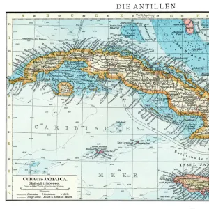
Geography Atlas: representation of the island of Santo Domingo in the West Indies. Map taken from an atlas by Antonio del Monte y Tejada (1783-1861) with portraits of Christopher Columbus, Bartolome de las Casas, the conquistador Juan Ponce de Leon
 with portraits of Christopher Columbus, Bartolome de las Casas, the conquistador Juan Ponce de Leon")
![]()
Wall Art and Photo Gifts from Fine Art Finder
Geography Atlas: representation of the island of Santo Domingo in the West Indies. Map taken from an atlas by Antonio del Monte y Tejada (1783-1861) with portraits of Christopher Columbus, Bartolome de las Casas, the conquistador Juan Ponce de Leon
VEN5031364 Geography Atlas: representation of the island of Santo Domingo in the West Indies. Map taken from an atlas by Antonio del Monte y Tejada (1783-1861) with portraits of Christopher Columbus, Bartolome de las Casas, the conquistador Juan Ponce de Leon, Pedro Santana and Gonzalo Fernandez de Oviedo. 1861. Biblioteca Jose Marti, Havana, Cuba.; (add.info.: Geography Atlas: representation of the island of Santo Domingo in the West Indies. Map taken from an atlas by Antonio del Monte y Tejada (1783-1861) with portraits of Christopher Columbus, Bartolome de las Casas, the conquistador Juan Ponce de Leon, Pedro Santana and Gonzalo Fernandez de Oviedo. 1861. Biblioteca Jose Marti, Havana, Cuba.); © Marage Photos
Media ID 38164398
© © Marage Photos / Bridgeman Images
Amerique (continent) Amerique Centrale Amerique Du Nord Browser Caraïbes Caribbean Caribbean Island Carte Geographique Central America Conquistador Dominium Etats Unis Geographical Map Geographie Haiti Navigateur Saint Domingue Stockravenna
FEATURES IN THESE COLLECTIONS
> Maps and Charts
> Early Maps
> North America
> Cuba
> Cuba Heritage Sites
> Old Havana and its Fortification System
> North America
> Cuba
> Havana
> North America
> Cuba
> Maps
> North America
> Cuba
> Related Images
> North America
> Haiti
> Maps
> North America
> Haiti
> Related Images
> North America
> United States of America
> Maps
> Popular Themes
> North Island
EDITORS COMMENTS
This stunning print of a Geography Atlas showcases the intricate representation of the island of Santo Domingo in the West Indies. The map, taken from an atlas by Antonio del Monte y Tejada, features portraits of historical figures such as Christopher Columbus, Bartolome de las Casas, Juan Ponce de Leon, Pedro Santana, and Gonzalo Fernandez de Oviedo.
Dating back to 1861 and housed in the Biblioteca Jose Marti in Havana, Cuba, this piece offers a glimpse into the rich history and exploration of the Caribbean region during the 19th century. The detailed engraving captures not only geographical features but also important personalities who played significant roles in shaping the destiny of these lands.
As we admire this artwork, we are transported back in time to an era when discovery and conquest were intertwined with ambition and courage. The presence of iconic figures like Columbus and De Las Casas reminds us of their enduring legacy and impact on world history.
This print serves as a window to the past, allowing us to appreciate both the beauty of cartography and the complexity of human interactions that have shaped our world. It is a testament to our curiosity about distant lands and our relentless quest for knowledge about our planet's diverse landscapes.
MADE IN AUSTRALIA
Safe Shipping with 30 Day Money Back Guarantee
FREE PERSONALISATION*
We are proud to offer a range of customisation features including Personalised Captions, Color Filters and Picture Zoom Tools
SECURE PAYMENTS
We happily accept a wide range of payment options so you can pay for the things you need in the way that is most convenient for you
* Options may vary by product and licensing agreement. Zoomed Pictures can be adjusted in the Cart.