Fine Art Print > Fine Art Storehouse > Map
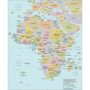
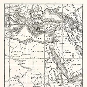
Fine Art Print : Africa political map 1895


![]()
Fine Art Prints from Fine Art Storehouse
Africa political map 1895
Meyers Konversations-Lexikon. Ein Nachschlagewerk des allgemeinen Wissens, 5th edition 17 volumes Bibliographisches Institut - Leipzig 1895-1897
Unleash your creativity and transform your space into a visual masterpiece!
THEPALMER
Media ID 13611775
© This content is subject to copyright
Algeria Atlas Mythological Figure Central Africa East Africa Egypt Madagascar Middle East Morocco North Africa Paper Politics Politics And Government Sahara Desert World Map
20"x16" (+3" Border) Fine Art Print
Step back in time with our exquisite Fine Art Print of the Africa Political Map from THEPALMER, published in the esteemed Meyers Konversations-Lexikon in 1895. This intricately detailed map offers a captivating glimpse into the political landscape of Africa during a pivotal moment in history. Each print is meticulously reproduced from the original edition, ensuring the highest quality and authenticity. Bring a piece of historical cartography into your home or office and transport yourself on a journey through time. Order now and add this unique addition to your collection.
20x16 image printed on 26x22 Fine Art Rag Paper with 3" (76mm) white border. Our Fine Art Prints are printed on 300gsm 100% acid free, PH neutral paper with archival properties. This printing method is used by museums and art collections to exhibit photographs and art reproductions.
Our fine art prints are high-quality prints made using a paper called Photo Rag. This 100% cotton rag fibre paper is known for its exceptional image sharpness, rich colors, and high level of detail, making it a popular choice for professional photographers and artists. Photo rag paper is our clear recommendation for a fine art paper print. If you can afford to spend more on a higher quality paper, then Photo Rag is our clear recommendation for a fine art paper print.
Estimated Image Size (if not cropped) is 40.6cm x 49.1cm (16" x 19.3")
Estimated Product Size is 55.9cm x 66cm (22" x 26")
These are individually made so all sizes are approximate
Artwork printed orientated as per the preview above, with portrait (vertical) orientation to match the source image.
FEATURES IN THESE COLLECTIONS
> Fine Art Storehouse
> The Magical World of Illustration
> Palmer Illustrated Collection
> Fine Art Storehouse
> Map
> Historical Maps
> Fine Art Storehouse
> Map
> USA Maps
> Fine Art Storehouse
> Travel Imagery
> Travel Destinations
> Morocco, North Africa
> Fine Art Storehouse
> Ultimate Earth Prints
> Amazing Deserts
EDITORS COMMENTS
This print showcases an extraordinary piece of history - the Africa political map from 1895. Taken from Meyers Konversations-Lexikon, a renowned encyclopedia of general knowledge, this atlas provides a fascinating glimpse into the world as it was over a century ago. The intricate details and exquisite craftsmanship of this engraved image transport us back to a time when cartography was both an art form and a tool for understanding our planet. The map spans across various regions, capturing the vastness and diversity of Africa. From the Middle East to Madagascar, Egypt to Morocco, every corner is meticulously depicted with accuracy and precision. The Sahara Desert stretches across its expansive landscape while countries like Algeria and Central Africa emerge with their distinct borders. As we delve deeper into this antique illustration, we are reminded of the significance that politics and government hold in shaping our world. This historical artifact serves as a reminder of how boundaries have shifted over time due to political changes and colonization. Printed on high-quality paper, this vertical masterpiece brings together physical geography and politics in one frame. It stands as not just an artistic representation but also as a testament to human curiosity about our surroundings. THEPALMER's skillful capture ensures that this remarkable piece can be cherished for generations to come – preserving not only the beauty of cartography but also offering us insights into our shared past.
MADE IN AUSTRALIA
Safe Shipping with 30 Day Money Back Guarantee
FREE PERSONALISATION*
We are proud to offer a range of customisation features including Personalised Captions, Color Filters and Picture Zoom Tools
SECURE PAYMENTS
We happily accept a wide range of payment options so you can pay for the things you need in the way that is most convenient for you
* Options may vary by product and licensing agreement. Zoomed Pictures can be adjusted in the Cart.