Fine Art Print > Africa > Egypt > Maps
Fine Art Print : Asia Minor, the Caucasus Region and Mesopotamia, First World War, c1915, (c1920)
")


![]()
Fine Art Prints from Heritage Images
Asia Minor, the Caucasus Region and Mesopotamia, First World War, c1915, (c1920)
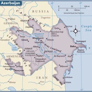
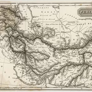
Asia Minor, the Caucasus Region and Mesopotamia, First World War, c1915, (c1920). Map of part of the Middle East, showing eastern Turkey, Cyprus, Syria, Lebanon, Palestine, northern Egypt and the Sinai, Iraq, Azerbaijan, Kurdistan, Georgia and Persia. From " The Great World War - A History" Volume IV, edited by Frank A Mumby. [The Gresham Publishing Company Ltd, London, c1920]
Heritage Images features heritage image collections
Media ID 19175465
© The Print Collector/Heritage Images
Asia Minor Azerbaijan Bartholomew Bartholomew And Co Bartholomew Co Bartholomew John Son Caucasus Caucasus Asia Cypro Cyprus Desert Disputed Territory Frank Arthur Frank Arthur Mumby Georgia Gresham Publishing Co Ltd Gresham Publishing Company Iran Iraq Jg Bartholomew John And Son John Bartholomew And Co John Bartholomew And Son John Bartholomew And Son Ltd John Bartholomew Co John Bartholomew Son John Bartholomew Son Ltd John Son Keystone Archives Kurdistan Lebanon Mediterranean Mesopotamia Mumby Mumby Frank Arthur Palestine Persia Sinai Sinai Egypt Syria Territorial Territory The Great World War A History Theatre Of War Turkey Turkish Mizraim
20"x16" (+3" Border) Fine Art Print
Step back in time with this captivating Fine Art Print from Media Storehouse, featuring a historic map of the Middle East by John Bartholomew & Son. Dated between 1915 and 1920, this exquisite piece showcases the regions of Asia Minor, the Caucasus, and Mesopotamia during the First World War. Explore the intricate details of the map, which highlights the territories of eastern Turkey, Cyprus, Syria, Lebanon, and Palestine. A perfect addition to any home or office, this Fine Art Print not only serves as a beautiful decorative piece but also as a reminder of historical events and geographical contexts. Immerse yourself in the rich history of this region with this stunning, vintage map print.
20x16 image printed on 26x22 Fine Art Rag Paper with 3" (76mm) white border. Our Fine Art Prints are printed on 300gsm 100% acid free, PH neutral paper with archival properties. This printing method is used by museums and art collections to exhibit photographs and art reproductions.
Our fine art prints are high-quality prints made using a paper called Photo Rag. This 100% cotton rag fibre paper is known for its exceptional image sharpness, rich colors, and high level of detail, making it a popular choice for professional photographers and artists. Photo rag paper is our clear recommendation for a fine art paper print. If you can afford to spend more on a higher quality paper, then Photo Rag is our clear recommendation for a fine art paper print.
Estimated Image Size (if not cropped) is 50.8cm x 37cm (20" x 14.6")
Estimated Product Size is 66cm x 55.9cm (26" x 22")
These are individually made so all sizes are approximate
Artwork printed orientated as per the preview above, with landscape (horizontal) orientation to match the source image.
FEATURES IN THESE COLLECTIONS
> Africa
> Egypt
> Related Images
> Animals
> Mammals
> Muridae
> Desert Mouse
> Arts
> Artists
> S
> Syrian Syrian
> Asia
> Azerbaijan
> Maps
> Asia
> Azerbaijan
> Related Images
> Asia
> Cyprus
> Related Images
> Asia
> Georgia
> Related Images
EDITORS COMMENTS
This print showcases a detailed map titled "Asia Minor, the Caucasus Region and Mesopotamia" during the First World War. Created around 1915 and published in Frank A Mumby's book "The Great World War - A History" this map provides a comprehensive view of the Middle East region at that time. The map encompasses various countries and territories, including eastern Turkey, Cyprus, Syria, Lebanon, Palestine, northern Egypt and the Sinai Peninsula. It also highlights Iraq, Azerbaijan, Kurdistan, Georgia, and Persia (modern-day Iran). The coastal areas along the Mediterranean Sea are beautifully depicted with vibrant colors. The significance of this historical document lies in its portrayal of disputed territories during one of the most tumultuous periods in history. It offers valuable insights into geopolitical boundaries and regional dynamics prevalent during the early 20th century. Created by John Bartholomew & Son – renowned cartographers from Scotland – this map is a testament to their expertise in capturing intricate geographical features with precision. Its inclusion in Mumby's volume adds scholarly value to understanding the impact of World War I on these regions. As we admire this remarkable piece of cartographic artistry today, it serves as a reminder of how borders have shifted over time while highlighting both historical connections and contemporary disputes within Asia Minor, Caucasus Region, and Mesopotamia.
MADE IN AUSTRALIA
Safe Shipping with 30 Day Money Back Guarantee
FREE PERSONALISATION*
We are proud to offer a range of customisation features including Personalised Captions, Color Filters and Picture Zoom Tools
SECURE PAYMENTS
We happily accept a wide range of payment options so you can pay for the things you need in the way that is most convenient for you
* Options may vary by product and licensing agreement. Zoomed Pictures can be adjusted in the Cart.