Fine Art Print > Arts > Artists > O > Oceanic Oceanic
Fine Art Print : EXPL2A-00065


![]()
Fine Art Prints from North Wind
EXPL2A-00065
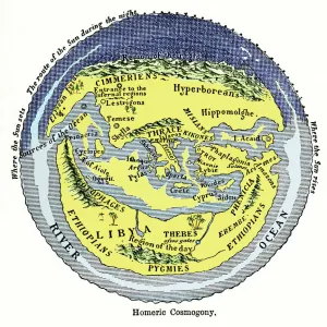
World map of the flat earth printed by Beatus Rhenanus Bildaus Rheinau early 1500s - North is left, Mediterranean Sea middle
Printed color lithograph reproduction 19th century
North Wind Picture Archives brings history to life with stock images and hand-colored illustrations
Media ID 5882012
© North Wind Picture Archives
1500s 16th Century Adventure Africa Asia Atlantic Ocean Cartography Chart Discover Europe Exploration Explore Fish Flat Earth Maritime Mediterranean Mediterranean Sea Navigation Ocean Travel World Beatus Libia Libya
21"x14" (+3" Border) Fine Art Print
Discover the captivating allure of history with our exquisite selection from the Media Storehouse Fine Art Prints range. This mesmerizing print, EXPL2A-00065 from North Wind Picture Archives, showcases a rare and intriguing world map created by Beatus Rhenanus in Rheinau during the early 1500s. A stunning 19th-century color lithograph reproduction, this print invites you to explore the flat earth theory as it was once imagined, with the Mediterranean Sea at its heart and the mysterious unknowns of the unexplored world beyond. Add a touch of history and intrigue to your space with this unique and captivating work of art.
21x14 image printed on 27x20 Fine Art Rag Paper with 3" (76mm) white border. Our Fine Art Prints are printed on 300gsm 100% acid free, PH neutral paper with archival properties. This printing method is used by museums and art collections to exhibit photographs and art reproductions.
Our fine art prints are high-quality prints made using a paper called Photo Rag. This 100% cotton rag fibre paper is known for its exceptional image sharpness, rich colors, and high level of detail, making it a popular choice for professional photographers and artists. Photo rag paper is our clear recommendation for a fine art paper print. If you can afford to spend more on a higher quality paper, then Photo Rag is our clear recommendation for a fine art paper print.
Estimated Image Size (if not cropped) is 53.3cm x 35.5cm (21" x 14")
Estimated Product Size is 68.6cm x 50.8cm (27" x 20")
These are individually made so all sizes are approximate
Artwork printed orientated as per the preview above, with landscape (horizontal) orientation to match the source image.
FEATURES IN THESE COLLECTIONS
> Africa
> Libya
> Related Images
> Africa
> Related Images
> Animals
> Fishes
> Related Images
> Arts
> Artists
> O
> Oceanic Oceanic
> Asia
> Related Images
> Maps and Charts
> Early Maps
> Maps and Charts
> Flat Earth
> Maps and Charts
> Related Images
> North Wind Picture Archives
> Maps
EDITORS COMMENTS
This vintage print takes us back to the early 1500s when cartography was still in its infancy. Titled "EXPL2A-00065" it showcases a world map of the flat earth, printed by Beatus Rhenanus Bildaus Rheinau. The unique aspect of this map is that North is depicted on the left side, contrary to our modern conventions. The Mediterranean Sea occupies the central position, serving as a pivotal point for navigation and trade routes during that era. The lithograph reproduction from the 19th century beautifully captures the intricate details and vibrant colors of the original artwork. As we explore this historic illustration, we can't help but notice various elements that reflect both adventure and maritime culture. Fish swim gracefully through oceans while ships sail across vast waters, symbolizing exploration and discovery. The chart encompasses Africa, Asia, Europe, and even Libya (Libia), providing a glimpse into how these regions were perceived at that time. It offers an intriguing insight into early cartography techniques and highlights how knowledge about our planet has evolved over centuries. This artful depiction serves as a reminder of humanity's curiosity about the world around us throughout history. Whether used for educational purposes or simply admired for its aesthetic appeal, this print invites us to embark on a journey through time where imagination meets reality.
MADE IN AUSTRALIA
Safe Shipping with 30 Day Money Back Guarantee
FREE PERSONALISATION*
We are proud to offer a range of customisation features including Personalised Captions, Color Filters and Picture Zoom Tools
SECURE PAYMENTS
We happily accept a wide range of payment options so you can pay for the things you need in the way that is most convenient for you
* Options may vary by product and licensing agreement. Zoomed Pictures can be adjusted in the Cart.