Home > North America > United States of America > New York > New York > Maps
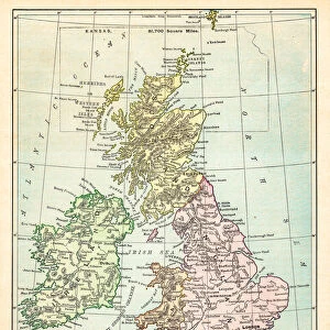
Biritsh Isles map 1881

![]()
Wall Art and Photo Gifts from Fine Art Storehouse
Biritsh Isles map 1881
Coltons Common School Geography 1881 New York Sheldon and Co
Unleash your creativity and transform your space into a visual masterpiece!
THEPALMER
Media ID 13669311
© This content is subject to copyright
Globe Navigational Equipment Ireland Paper Planet Earth Scotland World Map
FEATURES IN THESE COLLECTIONS
> Europe
> Republic of Ireland
> Maps
> Europe
> United Kingdom
> Maps
> Europe
> United Kingdom
> Scotland
> Maps
> Fine Art Storehouse
> The Magical World of Illustration
> Palmer Illustrated Collection
> Fine Art Storehouse
> Map
> Historical Maps
> Maps and Charts
> Early Maps
> Maps and Charts
> World
> North America
> United States of America
> Maps
> North America
> United States of America
> New York
> New York
> Maps
EDITORS COMMENTS
This print takes us back in time to the year 1881, showcasing a beautifully detailed map of the British Isles. The map is an exquisite piece from Coltons Common School Geography collection, published by Sheldon and Co in New York. Its vertical orientation allows for a comprehensive view of the United Kingdom, Scotland, Ireland, and even parts of the United States. Printed on aged paper, this antique engraving transports us to an era when globe navigational equipment was essential for explorers and cartographers alike. The intricate illustration captures the physical geography of our planet Earth with remarkable precision. As we gaze upon this vintage masterpiece created by THEPALMER from Fine Art Storehouse, we can't help but appreciate its historical significance. Each line meticulously engraved showcases the artistry involved in cartography during that period. The image evokes a sense of nostalgia as it reminds us of a time when maps were cherished possessions used for both practical navigation and aesthetic appreciation. It serves as a reminder that despite technological advancements in mapping today, there is still something enchanting about these old-world representations. Whether you are an avid collector or simply fascinated by history and geography, this extraordinary print will undoubtedly add charm and character to any space it graces.
MADE IN AUSTRALIA
Safe Shipping with 30 Day Money Back Guarantee
FREE PERSONALISATION*
We are proud to offer a range of customisation features including Personalised Captions, Color Filters and Picture Zoom Tools
SECURE PAYMENTS
We happily accept a wide range of payment options so you can pay for the things you need in the way that is most convenient for you
* Options may vary by product and licensing agreement. Zoomed Pictures can be adjusted in the Cart.