Home > Africa > Benin > Maps
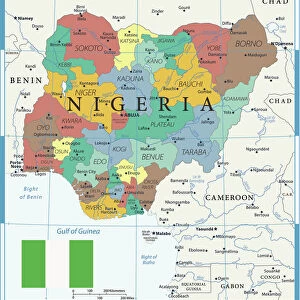
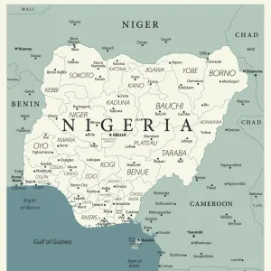
Photographic Print : Reference Map of Nigeria


![]()
Photo Prints from Fine Art Storehouse
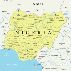
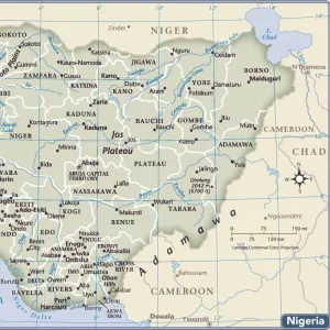
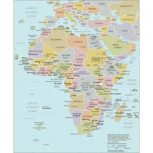
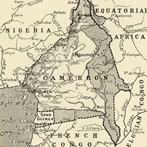
Reference Map of Nigeria
Nigeria is located in western Africa. Nigeria is bordered by the Gulf of Guinea, Benin to the west, Niger to the north, and Chad and Cameroon to the east
Unleash your creativity and transform your space into a visual masterpiece!
Media ID 20251057
10"x8" (25x20cm) Photo Print
Discover the rich cultural tapestry of Nigeria with our exquisite Fine Art Storehouse Photographic Prints. This captivating "Reference Map of Nigeria" print invites you on a visual journey through western Africa's most populous nation. Bordered by the Gulf of Guinea, Benin to the west, Niger to the north, and Chad and Cameroon to the east, this detailed map is a testament to Nigeria's diverse geography and storied history. Bring a piece of Africa's heart into your home or office with this stunning, high-quality photographic print. Order now and embark on a visual adventure!
Ideal for framing, Australian made Photo Prints are produced on high-quality 270 gsm lustre photo paper which has a subtle shimmer adding a touch of elegance, designed to enhance their visual appeal.
Our Photo Prints are in a large range of sizes and are printed on Archival Quality Paper for excellent colour reproduction and longevity. They are ideal for framing (our Framed Prints use these) at a reasonable cost. Alternatives include cheaper Poster Prints and higher quality Fine Art Paper, the choice of which is largely dependant on your budget.
Estimated Product Size is 20.3cm x 25.4cm (8" x 10")
These are individually made so all sizes are approximate
Artwork printed orientated as per the preview above, with portrait (vertical) orientation to match the source image.
FEATURES IN THESE COLLECTIONS
> Africa
> Benin
> Related Images
> Africa
> Cameroon
> Related Images
> Africa
> Chad
> Related Images
> Africa
> Guinea
> Related Images
> Africa
> Niger
> Related Images
EDITORS COMMENTS
This print showcases a meticulously detailed "Reference Map of Nigeria" offering a visual gateway to the diverse landscapes and geographical features of this vibrant West African nation. Nestled in the western part of Africa, Nigeria is bordered by the Gulf of Guinea on its southern coast, while Benin lies to its west. To the north, Niger forms a natural boundary, while Chad and Cameroon extend their embrace from the east. The map's intricate design invites exploration as it highlights not only Nigeria's expansive territory but also presents an opportunity to delve into its rich cultural tapestry. From lush rainforests and sprawling savannahs in the south to arid plains and majestic mountains up north, this map captures Nigeria's remarkable topography. Beyond geography alone, this print serves as an educational tool for those seeking knowledge about Nigeria's neighboring countries. It provides context by illustrating how these nations contribute to shaping Nigeria's history, culture, and regional dynamics. As a piece of fine art photography from Fine Art Storehouse that transcends commercial use limitations, this image evokes curiosity and sparks wanderlust. Whether displayed in classrooms or homes with an appreciation for cartography or African heritage alike, this reference map print offers both aesthetic appeal and valuable insights into one of Africa's most influential nations – inviting viewers on a journey through time and space within Nigerian borders.
MADE IN AUSTRALIA
Safe Shipping with 30 Day Money Back Guarantee
FREE PERSONALISATION*
We are proud to offer a range of customisation features including Personalised Captions, Color Filters and Picture Zoom Tools
SECURE PAYMENTS
We happily accept a wide range of payment options so you can pay for the things you need in the way that is most convenient for you
* Options may vary by product and licensing agreement. Zoomed Pictures can be adjusted in the Cart.