Framed Print > Maps and Charts > Africa
Framed Print : Antquie Map of Africa


![]()
Framed Photos from Fine Art Storehouse
Antquie Map of Africa
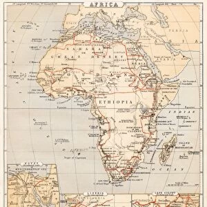
Vintage map of Africa from 1837
Unleash your creativity and transform your space into a visual masterpiece!
duncan1890
Media ID 13666423
© Duncan Walker
1830 1839 Geographical Locations Image Created 1830 1839 Latitude Longitude Navigational Equipment Past Styles Image Created 19th Century Victorian Style
13.5"x11.5" (34x29cm) Premium Frame
Step back in time with our exquisite Framed Print of the "Vintage Map of Africa" by duncan1890 from our Media Storehouse Fine Art collection. This captivating piece, originally created in 1837, showcases an intriguing and historical perspective of the African continent. The aged, antique map is beautifully framed, adding a touch of classic elegance and charm to any room. Ideal for history enthusiasts, world travelers, or those who appreciate the beauty of vintage art. Bring a piece of the past into your home today.
Framed and mounted 9x7 print. Professionally handmade full timber moulded frames are finished off with framers tape and come with a hanging solution on the back. Outer dimensions are 13.5x11.5 inches (34x29cm). Quality timber frame frame moulding (20mm wide and 30mm deep) with frame colours in your choice of black, white, or raw oak and a choice of black or white card mounts. Frames have a perspex front providing a virtually unbreakable glass-like finish which is easily cleaned with a damp cloth.
Contemporary Framed and Mounted Prints - Professionally Made and Ready to Hang
Estimated Image Size (if not cropped) is 21.4cm x 21.4cm (8.4" x 8.4")
Estimated Product Size is 34cm x 29.2cm (13.4" x 11.5")
These are individually made so all sizes are approximate
Artwork printed orientated as per the preview above, with landscape (horizontal) or portrait (vertical) orientation to match the source image.
FEATURES IN THESE COLLECTIONS
> Fine Art Storehouse
> Map
> Historical Maps
> Africa
> Related Images
> Maps and Charts
> Related Images
EDITORS COMMENTS
This print showcases an exquisite antique map of Africa, dating back to the year 1837. With its intricate details and Victorian-style engravings, this vintage piece offers a glimpse into the past and takes us on a journey through history. The map is adorned with navigational equipment symbols, highlighting the tools used by explorers during that era. The craftsmanship of this engraved image is truly remarkable, capturing the geographical locations of Africa with precision. Latitude and longitude lines crisscross the continent, providing an accurate representation of its vastness and diversity. This horizontal composition allows for easy exploration of each region's unique features. As we gaze upon this 19th-century masterpiece, we are transported to a time when photography was yet to be invented. The absence of people in the image further emphasizes its focus on showcasing Africa's natural beauty and rich heritage. Duncan1890 has skillfully preserved this historical artifact from over a century ago, allowing us to appreciate both its artistic value and educational significance. Whether you are an avid collector or simply fascinated by African history, this print serves as a timeless reminder of our shared past and invites us to delve into the mysteries that lie within these ancient lands.
MADE IN AUSTRALIA
Safe Shipping with 30 Day Money Back Guarantee
FREE PERSONALISATION*
We are proud to offer a range of customisation features including Personalised Captions, Color Filters and Picture Zoom Tools
SECURE PAYMENTS
We happily accept a wide range of payment options so you can pay for the things you need in the way that is most convenient for you
* Options may vary by product and licensing agreement. Zoomed Pictures can be adjusted in the Cart.