Poster Print > Maps and Charts > Africa
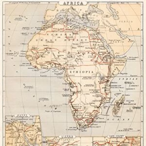
Poster Print : Antquie Map of Africa


![]()
Poster Prints from Fine Art Storehouse
Antquie Map of Africa
Vintage map of Africa from 1837
Unleash your creativity and transform your space into a visual masterpiece!
duncan1890
Media ID 13666423
© Duncan Walker
1830 1839 Geographical Locations Image Created 1830 1839 Latitude Longitude Navigational Equipment Past Styles Image Created 19th Century Victorian Style
A3 (42 x 29.7cm) Poster Print
"Step back in time with our exquisite Antique Map of Africa print from the Media Storehouse collection at Fine Art Storehouse. This vintage masterpiece, created by duncan1890 in 1837, offers a captivating glimpse into the historical cartography of Africa. Each print is meticulously reproduced to preserve the intricate details and authentic patina of the original map. Add an air of timeless sophistication to your space with this unique and intriguing piece of history."
Premium quality poster prints are printed on luxurious semi-gloss satin 270 gsm paper. Our meticulously crafted poster prints offer an affordable option for decorating any space, making them ideal for living rooms, bedrooms, offices and beyond. To ensure your poster arrives in good condition, we roll and send them in strong mailing tubes.
Poster prints are budget friendly enlarged prints in standard poster paper sizes (A0, A1, A2, A3 etc). Whilst poster paper is sometimes thinner and less durable than our other paper types, they are still ok for framing and should last many years. Our Archival Quality Photo Prints and Fine Art Paper Prints are printed on higher quality paper and the choice of which largely depends on your budget.
Estimated Product Size is 42.6cm x 30.6cm (16.8" x 12")
These are individually made so all sizes are approximate
Artwork printed orientated as per the preview above, with landscape (horizontal) orientation to match the source image.
FEATURES IN THESE COLLECTIONS
> Fine Art Storehouse
> Map
> Historical Maps
> Africa
> Related Images
> Maps and Charts
> Related Images
EDITORS COMMENTS
This print showcases an exquisite antique map of Africa, dating back to the year 1837. With its intricate details and Victorian-style engravings, this vintage piece offers a glimpse into the past and takes us on a journey through history. The map is adorned with navigational equipment symbols, highlighting the tools used by explorers during that era. The craftsmanship of this engraved image is truly remarkable, capturing the geographical locations of Africa with precision. Latitude and longitude lines crisscross the continent, providing an accurate representation of its vastness and diversity. This horizontal composition allows for easy exploration of each region's unique features. As we gaze upon this 19th-century masterpiece, we are transported to a time when photography was yet to be invented. The absence of people in the image further emphasizes its focus on showcasing Africa's natural beauty and rich heritage. Duncan1890 has skillfully preserved this historical artifact from over a century ago, allowing us to appreciate both its artistic value and educational significance. Whether you are an avid collector or simply fascinated by African history, this print serves as a timeless reminder of our shared past and invites us to delve into the mysteries that lie within these ancient lands.
MADE IN AUSTRALIA
Safe Shipping with 30 Day Money Back Guarantee
FREE PERSONALISATION*
We are proud to offer a range of customisation features including Personalised Captions, Color Filters and Picture Zoom Tools
SECURE PAYMENTS
We happily accept a wide range of payment options so you can pay for the things you need in the way that is most convenient for you
* Options may vary by product and licensing agreement. Zoomed Pictures can be adjusted in the Cart.