Framed Print > Europe > United Kingdom > Scotland > Maps
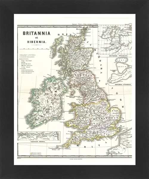
Framed Print : 1865, Spruner Map of the British Isles, England, Scotland, Ireland, topography, cartography


![]()
Framed Photos from Liszt Collection
1865, Spruner Map of the British Isles, England, Scotland, Ireland, topography, cartography
1865, Spruner Map of the British Isles, England, Scotland, Ireland
Liszt Collection of nineteenth-century engravings and images to browse and enjoy
Media ID 14006106
© Artokoloro Quint Lox Limited
Ireland Antique Map Latitude Longitude Mappa Mundi Old Antique Plan Old Antique View Ols Antique Map Rare Old Maps Topo
13.5"x11.5" (34x29cm) Premium Frame
Discover the rich history of the British Isles with our stunning Framed Print from the Media Storehouse Liszt Collection. This exquisite piece features the 1865 Spruner Map of England, Scotland, and Ireland, meticulously detailed with topographic and cartographic information from the year 1865. Add an air of sophistication and historical charm to your home or office decor with this beautiful framed print. Perfect for history enthusiasts, cartography lovers, or anyone seeking to add a unique touch to their space. Bring the past to life with this captivating piece from the Media Storehouse collection.
Framed and mounted 9x7 print. Professionally handmade full timber moulded frames are finished off with framers tape and come with a hanging solution on the back. Outer dimensions are 13.5x11.5 inches (34x29cm). Quality timber frame frame moulding (20mm wide and 30mm deep) with frame colours in your choice of black, white, or raw oak and a choice of black or white card mounts. Frames have a perspex front providing a virtually unbreakable glass-like finish which is easily cleaned with a damp cloth.
Contemporary Framed and Mounted Prints - Professionally Made and Ready to Hang
Estimated Image Size (if not cropped) is 21.4cm x 21.4cm (8.4" x 8.4")
Estimated Product Size is 29.2cm x 34cm (11.5" x 13.4")
These are individually made so all sizes are approximate
Artwork printed orientated as per the preview above, with landscape (horizontal) or portrait (vertical) orientation to match the source image.
FEATURES IN THESE COLLECTIONS
> Europe
> France
> Canton
> Landes
> Europe
> Republic of Ireland
> Maps
> Europe
> United Kingdom
> England
> Maps
> Europe
> United Kingdom
> Scotland
> Maps
> Europe
> United Kingdom
> Scotland
> Posters
> Europe
> United Kingdom
> Scotland
> Related Images
> Historic
> Space exploration
> Maps and Charts
> Early Maps
> Maps and Charts
> Related Images
EDITORS COMMENTS
This print showcases the remarkable 1865 Spruner Map of the British Isles, a true masterpiece in cartography. With intricate topographical details and meticulous accuracy, this map offers a glimpse into the geographical landscape of England, Scotland, and Ireland during that era. The vintage charm of this ancient map is evident through its delicate paper texture and retro aesthetic. Its historical significance cannot be overstated as it provides valuable insights into the world's past. The artistry involved in creating such a detailed illustration is truly commendable. As you explore this enchanting piece, you can almost envision the journeys and discoveries made by explorers who relied on maps like these to navigate uncharted territories. The grid lines representing latitude and longitude add an element of precision to this geographic treasure. This rare old map serves not only as a decorative item but also as a gateway to understanding our planet's history. It invites us to embark on an imaginary voyage back in time when exploration was at its peak. Whether you are an avid collector or simply fascinated by geography, this Spruner Map print from Liszt Collection will undoubtedly captivate your imagination with its rich historical narrative and timeless beauty.
MADE IN AUSTRALIA
Safe Shipping with 30 Day Money Back Guarantee
FREE PERSONALISATION*
We are proud to offer a range of customisation features including Personalised Captions, Color Filters and Picture Zoom Tools
SECURE PAYMENTS
We happily accept a wide range of payment options so you can pay for the things you need in the way that is most convenient for you
* Options may vary by product and licensing agreement. Zoomed Pictures can be adjusted in the Cart.