Framed Print > Maps and Charts > World
Framed Print : Maps / World / Eratosthenes


![]()
Framed Photos from Mary Evans Picture Library
Maps / World / Eratosthenes
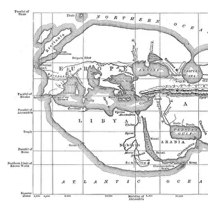
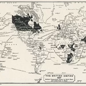
The world as known to Eratosthenes
Mary Evans Picture Library makes available wonderful images created for people to enjoy over the centuries
Media ID 581521
© Mary Evans Picture Library 2015 - https://copyrighthub.org/s0/hub1/creation/maryevans/MaryEvansPictureID/10027530
A2 Premium Frame with A3 Poster
Introducing the captivating "Maps / World / Eratosthenes" print from the Media Storehouse collection, brought to you by Mary Evans Picture Library. This exquisite framed print showcases an intriguing representation of the world as it was known to the ancient Greek scholar Eratosthenes. Eratosthenes, a renowned mathematician and geographer, is famous for being one of the first people to calculate the Earth's circumference with remarkable accuracy. This captivating image offers a glimpse into the world as it was understood during his time, filled with rich detail and historical significance. Bring the mysteries of ancient geography into your home or office with this stunning and educational framed print. The high-quality print is expertly framed to preserve its beauty and ensure a lasting impression. Explore the world of history with Media Storehouse's "Maps / World / Eratosthenes" print – a perfect addition to any space that appreciates the wonders of the past.
Premium Paradise Wooden Range A2 Premium Poster Frame (62x45cm) with A3 Poster (42x30cm) and mounted behind a white matt board to make your photo really stand out. FSC Certified and Rainforest Alliance Certified for environmental, social, and economic sustainably. High transparency tempered glass window with a smooth finished frame. Great for filling empty walls, decorating blank spaces, or creating eye-catching gallery walls. Frames arrive ready to hang. Sent with secure, protective packaging. Smooth wooden veneer mimics the real wood look and feel with ultra-durable scratch resistance tempered glass.
Contemporary Framed and Mounted Prints - Professionally Made and Ready to Hang
Estimated Image Size (if not cropped) is 40.4cm x 40.4cm (15.9" x 15.9")
Estimated Product Size is 62cm x 44.6cm (24.4" x 17.6")
These are individually made so all sizes are approximate
Artwork printed orientated as per the preview above, with landscape (horizontal) or portrait (vertical) orientation to match the source image.
FEATURES IN THESE COLLECTIONS
> Maps and Charts
> Early Maps
> Maps and Charts
> Popular Maps
> Maps and Charts
> Related Images
> Maps and Charts
> World
> Mary Evans Prints Online
> Maps
EDITORS COMMENTS
This image brings to life the world as it was known to the ancient Greek scholar Eratosthenes around 240 BC. Eratosthenes, a renowned mathematician and geographer, is celebrated for his groundbreaking contributions to the study of geography and the measurement of the Earth's size. In this evocative print from Mary Evans Picture Library, we see a beautifully detailed representation of the known world during Eratosthenes' time. The map, which is believed to be based on the works of the Greek cartographer Ptolemy, features the Mediterranean Sea at its center, surrounded by Europe, Africa, and Asia. The Nile River, the longest river in the ancient world, winds its way through the African continent, while the Red Sea and the Indian Ocean are also depicted. Eratosthenes' map is significant because it represents a major step forward in the history of cartography. Prior to his work, the world was believed to be flat, and maps were little more than rough sketches of the lands and seas known to the ancient civilizations. Eratosthenes, however, used simple yet ingenious methods to calculate the Earth's circumference with remarkable accuracy, and his map reflects a more accurate understanding of the world's geography. This print serves as a reminder of the incredible achievements of ancient scholars like Eratosthenes, whose curiosity and intellect paved the way for the scientific discoveries and advancements that have shaped our understanding of the world. It is a testament to the power of human curiosity and the enduring allure of the unknown, and a reminder of the importance of continuing to explore and learn about the world around us.
MADE IN AUSTRALIA
Safe Shipping with 30 Day Money Back Guarantee
FREE PERSONALISATION*
We are proud to offer a range of customisation features including Personalised Captions, Color Filters and Picture Zoom Tools
SECURE PAYMENTS
We happily accept a wide range of payment options so you can pay for the things you need in the way that is most convenient for you
* Options may vary by product and licensing agreement. Zoomed Pictures can be adjusted in the Cart.