Home > North America > Dominica > Maps
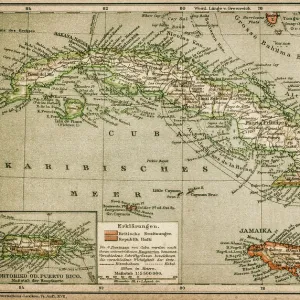
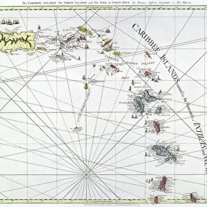
CARIBBEAN MAP, c1688. A map of the Caribbean islands. Woodcut, French, c1688

![]()
Wall Art and Photo Gifts from Granger
CARIBBEAN MAP, c1688. A map of the Caribbean islands. Woodcut, French, c1688
CARIBBEAN MAP, c1688.
A map of the Caribbean islands. Woodcut, French, c1688
Granger holds millions of images spanning more than 25,000 years of world history, from before the Stone Age to the dawn of the Space Age
Media ID 12321034
1688 Caribbean Caribbean Sea Coastline Guadeloupe Horizon Island New World Puerto Rico Sailing Ship South America Trinidad Typeface Archipelago Barbados Dominica Grenada Leeward Antilles Martinique Netherlands Antilles
FEATURES IN THESE COLLECTIONS
> Europe
> Netherlands
> Maps
> Granger Art on Demand
> Maps
> Maps and Charts
> Netherlands
> Maps and Charts
> World
> North America
> Barbados
> Maps
> North America
> Dominica
> Maps
> North America
> Grenada
> Maps
> North America
> Guadeloupe
> Maps
> North America
> Martinique
> Maps
> North America
> Puerto Rico
> Maps
EDITORS COMMENTS
The captivating "CARIBBEAN MAP, c1688" is a remarkable woodcut print that showcases the beauty and intricacy of the Caribbean islands during the late 17th century. Created by French cartographers, this map offers a glimpse into the maritime world of that era. With its detailed depiction of coastlines, islands, and surrounding waters, this map serves as an invaluable historical document. It highlights notable locations such as Barbados, Dominica, Grenada, Guadeloupe, Martinique, Puerto Rico, Trinidad and many more. The Leeward Antilles and Netherlands Antilles are also featured prominently. The woodcut technique used in creating this piece adds to its charm and authenticity. Each line and curve has been meticulously carved to bring out the rich textures of landmasses and sea waves alike. The typeface employed reflects the artistic sensibilities prevalent at that time. This print transports viewers back to an era when sailing ships dominated these turquoise waters while exploring new territories in South America. The horizon stretches endlessly before us as we imagine adventurers embarking on daring voyages across uncharted seas. Preserved by Granger Art on Demand from their extensive collection dating back centuries ago in New York City (NYC), this "CARIBBEAN MAP" not only celebrates history but also invites us to appreciate the natural beauty of these enchanting islands forever etched in time.
MADE IN AUSTRALIA
Safe Shipping with 30 Day Money Back Guarantee
FREE PERSONALISATION*
We are proud to offer a range of customisation features including Personalised Captions, Color Filters and Picture Zoom Tools
SECURE PAYMENTS
We happily accept a wide range of payment options so you can pay for the things you need in the way that is most convenient for you
* Options may vary by product and licensing agreement. Zoomed Pictures can be adjusted in the Cart.