Home > Arts > Landscape paintings > Waterfall and river artworks > River artworks
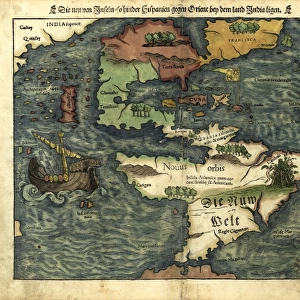
NORTH AMERICA: MAP, 1550. French planisphere of North America

![]()
Wall Art and Photo Gifts from Granger
NORTH AMERICA: MAP, 1550. French planisphere of North America
NORTH AMERICA: MAP, 1550.
French planisphere of North America
Granger holds millions of images spanning more than 25,000 years of world history, from before the Stone Age to the dawn of the Space Age
Media ID 12320979
1550 Age Of Discovery Canada Continent New World United States Planisphere
FEATURES IN THESE COLLECTIONS
> Arts
> Landscape paintings
> Waterfall and river artworks
> River artworks
> Granger Art on Demand
> Maps
> Maps and Charts
> World
> North America
> Canada
> Maps
EDITORS COMMENTS
This print titled "NORTH AMERICA: MAP, 1550" takes us back to the age of discovery and offers a glimpse into the intricate world of cartography during the Renaissance era. The French planisphere of North America depicted in this image showcases a fascinating perspective on the continent as it was known at that time. With its rich details and meticulous craftsmanship, this map invites us to explore the vastness of North America in 1550. From the rugged coastlines to meandering rivers, every feature is delicately illustrated, revealing both familiar landmarks and uncharted territories. It serves as a testament to the curiosity and ambition that characterized European exploration during this period. As we study this historical artifact, we are reminded of how much has changed since then. The boundaries have shifted, nations have risen and fallen, yet there is an undeniable sense of wonder that emanates from this piece. It transports us back to a time when maps were not just tools for navigation but also works of art meant to inspire awe and ignite curiosity about distant lands. Whether you are an avid history enthusiast or simply appreciate fine artistry, "NORTH AMERICA: MAP, 1550" by Granger Art on Demand captures a moment frozen in time—a reminder of our collective journey through discovery and exploration across continents.
MADE IN AUSTRALIA
Safe Shipping with 30 Day Money Back Guarantee
FREE PERSONALISATION*
We are proud to offer a range of customisation features including Personalised Captions, Color Filters and Picture Zoom Tools
SECURE PAYMENTS
We happily accept a wide range of payment options so you can pay for the things you need in the way that is most convenient for you
* Options may vary by product and licensing agreement. Zoomed Pictures can be adjusted in the Cart.