Greetings Card > Fine Art Storehouse > Map
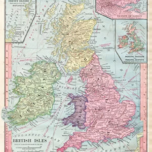
Greetings Card : map of the British isles 1856


![]()
Cards from Fine Art Storehouse
map of the British isles 1856
Colton and Fitchs Modern School Geography by George W. Fitch - New York 1856
Unleash your creativity and transform your space into a visual masterpiece!
THEPALMER
Media ID 13668781
© Roberto A Sanchez
Backgrounds British Culture Frame Grunge Grunge Image Technique Island Northern Ireland Paper Patina Republic Of Ireland Stained Textured Effect Obsolete Retro Styled
Greetings Card (7"x5")
Discover the charm of yesteryears with our Media Storehouse collection of vintage greeting cards. This exquisite design features an intricately detailed map of the British Isles, taken from the 1856 edition of Colton and Fitch's Modern School Geography by George W. Fitch, published in New York. The map, titled "THEPALMER," showcases the historical cartography of the British Isles during that era, making it a unique and thoughtful addition to your correspondence. Express your sentiments in a way that transcends time with these beautifully crafted, one-of-a-kind greeting cards.
Folded Greeting Cards (12.5x17.5 cm) have a laminate finish and are supplied with an envelope. The front and inside can be personalised with text in a selection of fonts, layouts and colours.
Greetings Cards suitable for Birthdays, Weddings, Anniversaries, Graduations, Thank You and much more
Estimated Product Size is 17.5cm x 12.5cm (6.9" x 4.9")
These are individually made so all sizes are approximate
Artwork printed orientated as per the preview above, with landscape (horizontal) or portrait (vertical) orientation to match the source image.
FEATURES IN THESE COLLECTIONS
> Fine Art Storehouse
> The Magical World of Illustration
> Palmer Illustrated Collection
> Fine Art Storehouse
> Map
> Historical Maps
EDITORS COMMENTS
This print showcases a vintage map of the British Isles from 1856, taken from George W. Fitch's "Colton and Fitchs Modern School Geography". The image exudes an air of nostalgia with its retro style and engraved technique, transporting us back to a bygone era. The stained and textured effect adds character to the piece, giving it a unique patina that speaks volumes about its age. The map itself is meticulously detailed, depicting England, Northern Ireland, Scotland, Wales, and the Republic of Ireland as they were over 150 years ago. It serves as both a historical artifact and a testament to the rich cultural heritage of these lands. Encased in an elegant frame, this engraving evokes feelings of curiosity and wonder about our past. Its vertical orientation further emphasizes its grandeur while adding visual interest to any space it graces. Whether you are an avid cartography enthusiast or simply appreciate art with depth and history, this print will undoubtedly captivate your imagination. It invites you on a journey through time while celebrating the beauty found within physical geography. "The Map of the British Isles 1856" by THEPALMER is more than just an image; it is a window into another world – one filled with old-world charm and timeless allure.
MADE IN AUSTRALIA
Safe Shipping with 30 Day Money Back Guarantee
FREE PERSONALISATION*
We are proud to offer a range of customisation features including Personalised Captions, Color Filters and Picture Zoom Tools
SECURE PAYMENTS
We happily accept a wide range of payment options so you can pay for the things you need in the way that is most convenient for you
* Options may vary by product and licensing agreement. Zoomed Pictures can be adjusted in the Cart.