Home > Battlefields of World War I
Land taken by Germany from Russia, First World War, 1915, (c1920). Creator: Unknown
. Creator: Unknown")
![]()
Wall Art and Photo Gifts from Heritage Images
Land taken by Germany from Russia, First World War, 1915, (c1920). Creator: Unknown
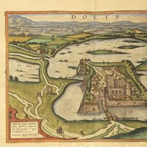
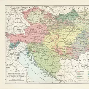
Land taken by Germany from Russia, First World War, 1915, (c1920). The Germanic Slice out of Russian Territory to the end of the Summer Campaign of 1915...territory gained by the Germans and lost to the Russians between the beginning of April and the end of September. From " The Great World War - A History" Volume IV, edited by Frank A Mumby. [The Gresham Publishing Company Ltd, London, c1920]
Heritage Images features heritage image collections
Media ID 19174423
© The Print Collector/Heritage Images
Austria Hungary Austro Hungarian Baltic Sea Disputed Territory Frank Arthur Frank Arthur Mumby Front Line Frontline Gresham Publishing Co Ltd Gresham Publishing Company Keystone Archives Mumby Mumby Frank Arthur Occupied Territory Poland Territorial Territory The Great World War A History Theatre Of War Warsaw Warsaw Poland 1st World War Battlefield
FEATURES IN THESE COLLECTIONS
> Europe
> Austria
> Related Images
> Europe
> France
> Canton
> Landes
> Europe
> Hungary
> Related Images
EDITORS COMMENTS
This print showcases the land taken by Germany from Russia during the First World War in 1915. The image, dating back to approximately 1920, provides a visual representation of the territorial changes that occurred during this tumultuous time. The Germanic Slice out of Russian Territory is depicted with remarkable detail, highlighting the coastal areas along the Baltic Sea. This disputed territory became a significant battleground between Germany and Russia throughout the summer campaign of 1915. As seen in this photograph, it vividly portrays the geographical features of this occupied territory. The historical significance of this image cannot be overstated as it captures a crucial moment in world history. It serves as a reminder of how borders were redrawn and nations fought for control over strategic locations during times of war. This particular print is sourced from "The Great World War - A History". Volume IV, edited by Frank A Mumby. Published by The Gresham Publishing Company Ltd in London around 1920, it offers valuable insights into one of humanity's most devastating conflicts. As we reflect upon these events from over a century ago, let us remember those who lived through these turbulent times and honor their sacrifices made on behalf of their respective countries.
MADE IN AUSTRALIA
Safe Shipping with 30 Day Money Back Guarantee
FREE PERSONALISATION*
We are proud to offer a range of customisation features including Personalised Captions, Color Filters and Picture Zoom Tools
SECURE PAYMENTS
We happily accept a wide range of payment options so you can pay for the things you need in the way that is most convenient for you
* Options may vary by product and licensing agreement. Zoomed Pictures can be adjusted in the Cart.