Jigsaw Puzzle > Europe > Denmark > Maps
Jigsaw Puzzle : Map of Baltic Sea and Europe


![]()
Jigsaw Puzzles From Fine Art Storehouse
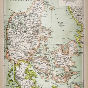
Map of Baltic Sea and Europe
Unleash your creativity and transform your space into a visual masterpiece!
Hemera Technologies
Media ID 13597685
© Getty Images
Antiquity Baltic Sea Continent Denmark Geographic Geographical Geography Text
Jigsaw Puzzle (1000 Pieces)
Discover the wonders of geography with our captivating Map of Baltic Sea and Europe jigsaw puzzle from the Media Storehouse collection, brought to you by Hemera Technologies from Fine Art Storehouse. This intricately detailed puzzle features an elegant and informative map design, showcasing the intricacies of the Baltic Sea and the surrounding European countries. Ideal for puzzle enthusiasts of all ages and skill levels, this puzzle not only provides hours of engaging entertainment but also serves as a beautiful decorative piece once completed. Immerse yourself in the world of cartography and expand your knowledge of Europe's rich history and culture. Get ready to embark on a fascinating journey with our Map of Baltic Sea and Europe puzzle.
1000 piece puzzles are custom made in Australia and hand-finished on 100% recycled 1.6mm thick laminated puzzle boards. There is a level of repetition in jigsaw shapes with each matching piece away from its pair. The completed puzzle measures 76x50cm and is delivered packaged in an attractive presentation box specially designed to fit most mail slots with a unique magnetic lid
Jigsaw Puzzles are an ideal gift for any occasion
Estimated Product Size is 76cm x 50.2cm (29.9" x 19.8")
These are individually made so all sizes are approximate
Artwork printed orientated as per the preview above, with landscape (horizontal) or portrait (vertical) orientation to match the source image.
FEATURES IN THESE COLLECTIONS
> Europe
> Denmark
> Related Images
> Maps and Charts
> Early Maps
> Maps and Charts
> Related Images
EDITORS COMMENTS
This print showcases a remarkable piece of history - the Map of Baltic Sea and Europe. With its antiquity and archival value, this map takes us back in time to explore the geographical wonders of the continent. The intricate cartography skillfully depicts the vastness of both land and sea, offering a glimpse into ancient civilizations that once thrived along these shores. The vibrant colors bring life to this vintage masterpiece, allowing us to appreciate every detail meticulously captured by Hemera Technologies. As we study this horizontal composition, our eyes wander across Denmark's coastline, tracing the contours of Europe's northernmost region. Beyond its aesthetic appeal, this photograph serves as a valuable resource for historians and geographers alike. It offers insights into physical geography during an era long gone by and sheds light on how societies interacted with their environment centuries ago. While no people are present in this image, it invites viewers to embark on a journey through time - immersing themselves in historical narratives woven within each contour line and text annotation. This map is not just an artistic representation; it is a window into our past. Whether displayed in educational institutions or private collections, this Fine Art Storehouse print holds immense cultural significance. It reminds us of our connection to those who came before us while inspiring curiosity about the world they inhabited.
MADE IN AUSTRALIA
Safe Shipping with 30 Day Money Back Guarantee
FREE PERSONALISATION*
We are proud to offer a range of customisation features including Personalised Captions, Color Filters and Picture Zoom Tools
SECURE PAYMENTS
We happily accept a wide range of payment options so you can pay for the things you need in the way that is most convenient for you
* Options may vary by product and licensing agreement. Zoomed Pictures can be adjusted in the Basket.