Jigsaw Puzzle > Arts > Artists > S > John Speed
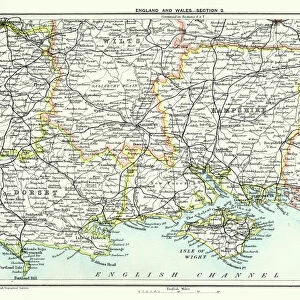
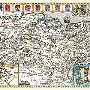
Jigsaw Puzzle : Old County Map of Derbyshire 1611 by John Speed


![]()
Jigsaw Puzzles from MapSeeker
Old County Map of Derbyshire 1611 by John Speed
A facimile of John Speeds historical map of Derbyshire originally published for the " Theatre of the Empire of Great Britain", an atlas to accompany " a history of Great Britain"
Welcome to the Mapseeker Image library and enter an historic gateway to one of the largest on-line collections of Historic Maps, Nostalgic Views, Vista's and Panorama's from a World gone by.
Media ID 20347969
© Mapseeker Publishing Ltd
County Map County Map Of England English County Map Historic Map John Speed Map Old County Map Old English County Map Speed Map Speede Map Derbyshire
Jigsaw Puzzle (1000 Pieces)
Discover the rich history of Derbyshire with our captivating Old County Map of Derbyshire 1611 by John Speed from Media Storehouse. This intricately detailed jigsaw puzzle is a faithful representation of the original map published for the "Theatre of the Empire of Great Britain" by renowned cartographer John Speed. Immerse yourself in the intricacies of this historical puzzle, bringing to life the landscapes, towns, and villages of Derbyshire as they appeared over 400 years ago. Connect the past with the present as you piece together this stunning piece of cartographic history. Perfect for history enthusiasts, puzzle lovers, or anyone looking to add a touch of nostalgia to their home.
1000 piece puzzles are custom made in Australia and hand-finished on 100% recycled 1.6mm thick laminated puzzle boards. There is a level of repetition in jigsaw shapes with each matching piece away from its pair. The completed puzzle measures 76x50cm and is delivered packaged in an attractive presentation box specially designed to fit most mail slots with a unique magnetic lid
Jigsaw Puzzles are an ideal gift for any occasion
Estimated Product Size is 76cm x 50.2cm (29.9" x 19.8")
These are individually made so all sizes are approximate
Artwork printed orientated as per the preview above, with landscape (horizontal) or portrait (vertical) orientation to match the source image.
FEATURES IN THESE COLLECTIONS
> Arts
> Artists
> S
> John Speed
> Europe
> United Kingdom
> England
> Derbyshire
> Related Images
> Europe
> United Kingdom
> England
> Maps
> Maps and Charts
> British Empire Maps
> Maps and Charts
> Early Maps
> Maps and Charts
> Related Images
> MapSeeker
> Maps from the British Isles
> England and Counties PORTFOLIO
EDITORS COMMENTS
Step back in time with this exquisite print of the 'Old County Map of Derbyshire 1611' by John Speed. A true testament to the rich history and intricate craftsmanship, this facsimile captures every detail of Speed's original masterpiece. Originally published as part of his renowned atlas, 'The Theatre of the Empire of Great Britain', this map was created to accompany a comprehensive history of Great Britain. It offers a fascinating glimpse into the past, showcasing the boundaries and landmarks that shaped Derbyshire during the early 17th century. With its elegant calligraphy and beautifully illustrated cartouches, this old English county map is a treasure trove for historians, geography enthusiasts, or anyone captivated by England's heritage. The meticulous attention to detail transports you back in time as you explore each village, river, and hill depicted on this historical gem. Derbyshire comes alive through Speed's expert handiwork – from bustling market towns like Derby itself to picturesque landscapes dotted with ancient castles and manor houses. This print allows you to trace your ancestors' footsteps or simply marvel at how much has changed over centuries while appreciating what remains unchanged. Whether adorning your study wall or serving as an educational tool in classrooms or libraries, this authentic reproduction brings both beauty and knowledge into any space. Immerse yourself in Derbyshire's past with this remarkable piece – a must-have for any lover of maps or British history.
MADE IN AUSTRALIA
Safe Shipping with 30 Day Money Back Guarantee
FREE PERSONALISATION*
We are proud to offer a range of customisation features including Personalised Captions, Color Filters and Picture Zoom Tools
SECURE PAYMENTS
We happily accept a wide range of payment options so you can pay for the things you need in the way that is most convenient for you
* Options may vary by product and licensing agreement. Zoomed Pictures can be adjusted in the Cart.