Jigsaw Puzzle > Europe > United Kingdom > Scotland > Strathclyde > Dumbarton
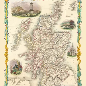
Jigsaw Puzzle : Old Map of the County of Dumbarton from the Philips Handy Atlas of 1882


![]()
Jigsaw Puzzles from MapSeeker
Old Map of the County of Dumbarton from the Philips Handy Atlas of 1882
PHA008
Welcome to the Mapseeker Image library and enter an historic gateway to one of the largest on-line collections of Historic Maps, Nostalgic Views, Vista's and Panorama's from a World gone by.
Media ID 20348028
County Map County Map Of Scotland Historic Map Old County Map Old Scottish County Map Dumbarton Dumbartonshire Dunbartonshire
Jigsaw Puzzle (500 Pieces)
Discover the charm of the past with Media Storehouse's Jigsaw Puzzle featuring an Old Map of Dumbarton County from the Philips Handy Atlas of 1882. This intricately detailed puzzle showcases the historical cartography of the County of Dumbarton as it appeared over a century ago. Immerse yourself in the beauty of the intricate lines and borders, and let the puzzle pieces transport you back in time. Perfect for puzzle enthusiasts, history buffs, or anyone looking to add a touch of nostalgia to their home, this puzzle promises a satisfying challenge and a journey through history with every piece placed. Bring the past to life with Media Storehouse's Old Map of Dumbarton County Jigsaw Puzzle.
500 piece puzzles are custom made in Australia and hand-finished on 100% recycled 1.6mm thick laminated puzzle boards. There is a level of repetition in jigsaw shapes with each matching piece away from its pair. The completed puzzle measures 40x51cm and is delivered packaged in an attractive presentation box specially designed to fit most mail slots with a unique magnetic lid
Jigsaw Puzzles are an ideal gift for any occasion
Estimated Product Size is 50.7cm x 40.3cm (20" x 15.9")
These are individually made so all sizes are approximate
Artwork printed orientated as per the preview above, with landscape (horizontal) or portrait (vertical) orientation to match the source image.
FEATURES IN THESE COLLECTIONS
> Europe
> United Kingdom
> Scotland
> Dumbarton
> Europe
> United Kingdom
> Scotland
> Maps
> Europe
> United Kingdom
> Scotland
> Strathclyde
> Dumbarton
> Maps and Charts
> Early Maps
> Maps and Charts
> Related Images
> MapSeeker
> Maps from the British Isles
> Scotland and Counties PORTFOLIO
EDITORS COMMENTS
This print showcases an exquisite piece of history - the Old Map of the County of Dumbarton from the Philips Handy Atlas of 1882. Steeped in Scottish heritage, this vintage county map offers a glimpse into the past, transporting us to a bygone era. With intricate details and delicate craftsmanship, this old Scottish county map is a testament to the artistry and precision that went into cartography during that time. It beautifully captures the boundaries and landmarks of Dunbartonshire, providing a fascinating insight into its historical geography. As we explore this historic map, we are reminded of how landscapes have evolved over time. From bustling towns like Dumbarton to serene countryside dotted with villages and hamlets, every corner tells a story waiting to be discovered. The rivers winding through lush green valleys and mountains standing tall in their majestic glory evoke a sense of awe for nature's grandeur. This remarkable piece serves as more than just decorative wall art; it is an educational tool that sparks curiosity about our ancestors' lives and their connection to these lands. Whether you have ancestral ties or simply appreciate Scotland's rich cultural heritage, this old county map will undoubtedly transport you back in time
MADE IN AUSTRALIA
Safe Shipping with 30 Day Money Back Guarantee
FREE PERSONALISATION*
We are proud to offer a range of customisation features including Personalised Captions, Color Filters and Picture Zoom Tools
SECURE PAYMENTS
We happily accept a wide range of payment options so you can pay for the things you need in the way that is most convenient for you
* Options may vary by product and licensing agreement. Zoomed Pictures can be adjusted in the Cart.