Jigsaw Puzzle > Arts > Artists > M > Gerardus Mercator
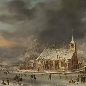
Jigsaw Puzzle : Septentrionalium Terrarum descriptio, 1595, by Gerardus Merc


![]()
Jigsaw Puzzles from Mary Evans Picture Library
Septentrionalium Terrarum descriptio, 1595, by Gerardus Merc
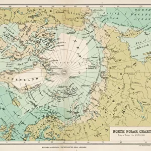
Gerardus Mercator (1512-1594). Flemish cartographer. Septentrionalium Terrarum descriptio. Map of the Arctic with the North Pole and surrounding lands within and outside the Arctic Circle, 1595
Mary Evans Picture Library makes available wonderful images created for people to enjoy over the centuries
Media ID 14330268
© Thaliastock / Mary Evans
1595 Arctic Area Carthography Cartographer Cartography Circle Descriptio Earth Flanders Flemish Gerard Gerardus Globe Kremer Latin Letter Letters Mathematician Mercator Netherlands Philosopher Philosophy Pole Surrounding Terrarum Terrestrial
Jigsaw Puzzle (500 Pieces)
Discover the captivating world of exploration and cartography with our Media Storehouse Jigsaw Puzzles, featuring the intricately detailed and historic map "Septentrionalium Terrarum descriptio" by Gerardus Mercator. Dated 1595, this beautifully preserved print from Mary Evans Prints Online invites you to piece together the mysteries of the Arctic, home to the North Pole and the lands within and outside the Arctic Circle. Embark on an educational and entertaining journey, assembling this jigsaw puzzle that not only challenges your problem-solving skills but also provides an insight into the fascinating history of cartography and the early European understanding of the Arctic region. Experience the thrill of discovery as you bring this exquisite piece of history back to life.
500 piece puzzles are custom made in Australia and hand-finished on 100% recycled 1.6mm thick laminated puzzle boards. There is a level of repetition in jigsaw shapes with each matching piece away from its pair. The completed puzzle measures 40x51cm and is delivered packaged in an attractive presentation box specially designed to fit most mail slots with a unique magnetic lid
Jigsaw Puzzles are an ideal gift for any occasion
Estimated Product Size is 50.7cm x 40.3cm (20" x 15.9")
These are individually made so all sizes are approximate
Artwork printed orientated as per the preview above, with landscape (horizontal) or portrait (vertical) orientation to match the source image.
FEATURES IN THESE COLLECTIONS
> Arts
> Artists
> M
> Gerardus Mercator
> Europe
> France
> Canton
> Landes
> Europe
> Netherlands
> Maps
> Europe
> Netherlands
> Posters
> Europe
> Netherlands
> Related Images
> Europe
> Related Images
> Maps and Charts
> Early Maps
> Maps and Charts
> Gerardus Mercator's Cartographic
> Maps and Charts
> Netherlands
> Maps and Charts
> Related Images
Septentrionalium Terrarum Descriptio,
EDITORS COMMENTS
a captivating masterpiece created by the renowned Flemish cartographer Gerardus Mercator in 1595, offers a glimpse into the intriguing world of Arctic exploration during the late 16th century. This meticulously crafted map, also known as "Description of the Northern Lands," provides a detailed representation of the Arctic region and the lands situated within and beyond the Arctic Circle. Mercator, a mathematician, philosopher, and cartographer, was a pioneer in the modern age of cartography. His expertise in mapmaking was unparalleled, and his works significantly advanced the understanding of the terrestrial world during the European Renaissance. This engraving, produced in Flanders, showcases Mercator's unwavering dedication to accurate geographical representation. The map's central focus is the Arctic Circle, with the North Pole at its heart. The intricate detailing of the surrounding seas, including the Greenland Sea, the Norwegian Sea, and the Arctic Ocean, reveals the extensive knowledge Mercator had acquired through various sources, such as explorers' accounts and previous maps. The map also features the lettered labels identifying various lands, islands, and waterways, providing valuable context for the viewer. Septentrionalium Terrarum Descriptio serves as a testament to Mercator's unwavering curiosity and commitment to expanding human knowledge of the world. This map not only represents a significant contribution to the history of cartography but also offers a fascinating glimpse into the European exploration of the Arctic during the late 16th century.
MADE IN AUSTRALIA
Safe Shipping with 30 Day Money Back Guarantee
FREE PERSONALISATION*
We are proud to offer a range of customisation features including Personalised Captions, Color Filters and Picture Zoom Tools
SECURE PAYMENTS
We happily accept a wide range of payment options so you can pay for the things you need in the way that is most convenient for you
* Options may vary by product and licensing agreement. Zoomed Pictures can be adjusted in the Cart.