Jigsaw Puzzle > Arts > Artists > P > Polynesian Polynesian
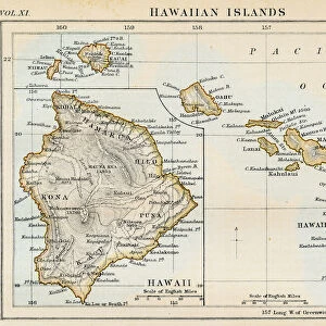
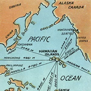
Jigsaw Puzzle : Map of Hawaii, 1870s


![]()
Jigsaw Puzzles from North Wind
Map of Hawaii, 1870s
Map of the Hawaiian islands, 1870s.
Color lithograph reproduction of a 19th-century illustration
North Wind Picture Archives brings history to life with stock images and hand-colored illustrations
Media ID 5882575
© North Wind Picture Archives
1870s Hawaii Hawaiian Hawaiian Islands Island Pacific Pacific Island Pacific Ocean Polynesia Polynesian Sandwich Islands
Jigsaw Puzzle (1000 Pieces)
Discover the rich history of Hawaii with our exquisite "Map of Hawaii, 1870s" jigsaw puzzle from Media Storehouse. This captivating puzzle features a stunning color lithograph reproduction of a rare 19th-century illustration from North Wind Picture Archives. Travel back in time as you piece together this intricate puzzle and explore the intricacies of the Hawaiian islands as they were depicted during this fascinating era. Engage in a fun and educational experience that the whole family can enjoy. Bring history to life with the Media Storehouse collection of jigsaw puzzles.
1000 piece puzzles are custom made in Australia and hand-finished on 100% recycled 1.6mm thick laminated puzzle boards. There is a level of repetition in jigsaw shapes with each matching piece away from its pair. The completed puzzle measures 76x50cm and is delivered packaged in an attractive presentation box specially designed to fit most mail slots with a unique magnetic lid
Jigsaw Puzzles are an ideal gift for any occasion
Estimated Product Size is 76cm x 50.2cm (29.9" x 19.8")
These are individually made so all sizes are approximate
Artwork printed orientated as per the preview above, with landscape (horizontal) or portrait (vertical) orientation to match the source image.
FEATURES IN THESE COLLECTIONS
> Arts
> Artists
> O
> Oceanic Oceanic
> Arts
> Artists
> P
> Polynesian Polynesian
> Maps and Charts
> Related Images
> North America
> Related Images
> Popular Themes
> North Island
> North Wind Picture Archives
> Maps
EDITORS COMMENTS
This print showcases a vibrant and historically significant "Map of Hawaii, 1870s". The color lithograph reproduction beautifully captures the essence of this 19th-century illustration, offering viewers a glimpse into the rich heritage and traditional roots of the Hawaiian islands. The map itself is an intricate depiction of the archipelago's geography, showcasing its position in the vast Pacific Ocean. It serves as a testament to Hawaii's unique place within Polynesia and its historical ties to both American and Polynesian cultures. With meticulous detail, this vintage artwork highlights various landmarks and regions that make up the Hawaiian islands. From lush green landscapes to sparkling blue waters, it transports us back in time to experience how these Pacific islands appeared during the late 1800s. As we explore this piece further, we can't help but appreciate its historical significance. It reminds us of Hawaii's journey from being known as Sandwich Islands to becoming an integral part of the United States' history. This artful representation invites us to delve deeper into Hawaiian history while also appreciating it as a work of art. Whether you are fascinated by cartography or simply drawn to vintage illustrations, this Map of Hawaii from North Wind Picture Archives is sure to captivate your imagination with its beauty and cultural importance.
MADE IN AUSTRALIA
Safe Shipping with 30 Day Money Back Guarantee
FREE PERSONALISATION*
We are proud to offer a range of customisation features including Personalised Captions, Color Filters and Picture Zoom Tools
SECURE PAYMENTS
We happily accept a wide range of payment options so you can pay for the things you need in the way that is most convenient for you
* Options may vary by product and licensing agreement. Zoomed Pictures can be adjusted in the Cart.