Poster Print > Arts > Artists > P > Polynesian Polynesian
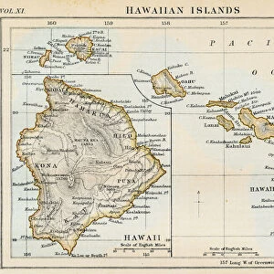
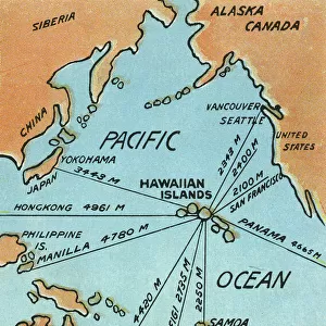
Poster Print : Map of Hawaii, 1870s


![]()
Poster Prints from North Wind
Map of Hawaii, 1870s
Map of the Hawaiian islands, 1870s.
Color lithograph reproduction of a 19th-century illustration
North Wind Picture Archives brings history to life with stock images and hand-colored illustrations
Media ID 5882575
© North Wind Picture Archives
1870s Hawaii Hawaiian Hawaiian Islands Island Pacific Pacific Island Pacific Ocean Polynesia Polynesian Sandwich Islands
A4 (29.7 x 21cm) Poster Print
Discover the rich history of Hawaii with our exquisite Map of Hawaii, 1870s poster print from Media Storehouse and North Wind Picture Archives. This captivating color lithograph reproduction transports you back in time, offering a fascinating glimpse into the 19th-century illustration of the Hawaiian islands. Bring the nostalgic charm of the past into your home or office space and add an educational and visually stunning addition to your decor. Immerse yourself in the history of this beautiful archipelago and let this timeless piece spark intrigue and conversation among visitors. Order your Map of Hawaii, 1870s poster print today and embark on a journey through history.
Premium quality poster prints are printed on luxurious semi-gloss satin 270 gsm paper. Our meticulously crafted poster prints offer an affordable option for decorating any space, making them ideal for living rooms, bedrooms, offices and beyond. To ensure your poster arrives in good condition, we roll and send them in strong mailing tubes.
Poster prints are budget friendly enlarged prints in standard poster paper sizes (A0, A1, A2, A3 etc). Whilst poster paper is sometimes thinner and less durable than our other paper types, they are still ok for framing and should last many years. Our Archival Quality Photo Prints and Fine Art Paper Prints are printed on higher quality paper and the choice of which largely depends on your budget.
Estimated Image Size (if not cropped) is 30.3cm x 20.7cm (11.9" x 8.1")
Estimated Product Size is 30.3cm x 21.6cm (11.9" x 8.5")
These are individually made so all sizes are approximate
Artwork printed orientated as per the preview above, with landscape (horizontal) orientation to match the source image.
FEATURES IN THESE COLLECTIONS
> North Wind Picture Archives
> Maps
> Arts
> Artists
> O
> Oceanic Oceanic
> Arts
> Artists
> P
> Polynesian Polynesian
> Maps and Charts
> Related Images
> North America
> Related Images
> Popular Themes
> North Island
EDITORS COMMENTS
This print showcases a vibrant and historically significant "Map of Hawaii, 1870s". The color lithograph reproduction beautifully captures the essence of this 19th-century illustration, offering viewers a glimpse into the rich heritage and traditional roots of the Hawaiian islands. The map itself is an intricate depiction of the archipelago's geography, showcasing its position in the vast Pacific Ocean. It serves as a testament to Hawaii's unique place within Polynesia and its historical ties to both American and Polynesian cultures. With meticulous detail, this vintage artwork highlights various landmarks and regions that make up the Hawaiian islands. From lush green landscapes to sparkling blue waters, it transports us back in time to experience how these Pacific islands appeared during the late 1800s. As we explore this piece further, we can't help but appreciate its historical significance. It reminds us of Hawaii's journey from being known as Sandwich Islands to becoming an integral part of the United States' history. This artful representation invites us to delve deeper into Hawaiian history while also appreciating it as a work of art. Whether you are fascinated by cartography or simply drawn to vintage illustrations, this Map of Hawaii from North Wind Picture Archives is sure to captivate your imagination with its beauty and cultural importance.
MADE IN AUSTRALIA
Safe Shipping with 30 Day Money Back Guarantee
FREE PERSONALISATION*
We are proud to offer a range of customisation features including Personalised Captions, Color Filters and Picture Zoom Tools
SECURE PAYMENTS
We happily accept a wide range of payment options so you can pay for the things you need in the way that is most convenient for you
* Options may vary by product and licensing agreement. Zoomed Pictures can be adjusted in the Cart.