Jigsaw Puzzle > Europe > France > Paris > Maps
Jigsaw Puzzle : 1740 Zatta Map Of Central France And The Vicinity Of Paris


![]()
Jigsaw Puzzles from Universal Images Group (UIG)
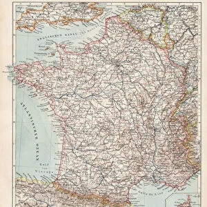
1740 Zatta Map Of Central France And The Vicinity Of Paris
1740, Zatta Map of Central France and the Vicinity of Paris
Universal Images Group (UIG) manages distribution for many leading specialist agencies worldwide
Media ID 38550200
© Artokoloro Quint Lox Limited
1740 Antique Map Latitude Longitude Mappa Mundi Old Antique Plan Old Antique View Ols Antique Map Rare Old Maps Topo
Jigsaw Puzzle (500 Pieces)
"Get lost in the charm of 18th century cartography with our Media Storehouse jigsaw puzzle featuring a stunning reproduction of '1740 Zatta Map of Central France and the Vicinity of Paris' from Universal Images Group (UIG). This intricate puzzle piece is a treasure trove for history buffs, geography enthusiasts, and anyone who loves to unwind with a good challenge. With its beautiful illustration and detailed design, this jigsaw puzzle is sure to transport you back in time to an era of grandeur and discovery."
500 piece puzzles are custom made in Australia and hand-finished on 100% recycled 1.6mm thick laminated puzzle boards. There is a level of repetition in jigsaw shapes with each matching piece away from its pair. The completed puzzle measures 40x51cm and is delivered packaged in an attractive presentation box specially designed to fit most mail slots with a unique magnetic lid
Jigsaw Puzzles are an ideal gift for any occasion
Estimated Product Size is 50.7cm x 40.3cm (20" x 15.9")
These are individually made so all sizes are approximate
Artwork printed orientated as per the preview above, with landscape (horizontal) or portrait (vertical) orientation to match the source image.
FEATURES IN THESE COLLECTIONS
> Animals
> Fishes
> G
> Grouper
> Europe
> France
> Canton
> Landes
> Europe
> France
> Paris
> Maps
> Historic
> Space exploration
> Maps and Charts
> Early Maps
> Maps and Charts
> Related Images
> Maps and Charts
> World
> Universal Images Group (UIG)
> History
> Historical Maps
EDITORS COMMENTS
Step back in time to the 18th century with this exquisite print of the 1740 Zatta Map of Central France and the Vicinity of Paris. Created by Italian cartographer Antonio Zatta, this stunning map is a masterpiece of topography and cartography. The intricate illustration depicts the region's geography, showcasing its winding rivers, rolling hills, and bustling cities.
The map's geometric design is characteristic of Zatta's style, featuring a grid-like layout that allows for precise navigation. Latitude and longitude lines are carefully marked, providing an accurate representation of the region's spatial relationships. The vintage aesthetic adds a touch of nostalgia to this historic document, making it a beautiful addition to any room or office.
This rare old map offers a glimpse into the past, revealing how our understanding of geography has evolved over time. It also serves as a testament to human ingenuity and exploration, highlighting our enduring fascination with mapping and charting the world around us.
Whether you're an history buff or simply appreciate unique pieces of artistry, this print is sure to captivate your senses. Its aged beauty makes it perfect for framing and display on your wall or using as inspiration for creative projects.
MADE IN AUSTRALIA
Safe Shipping with 30 Day Money Back Guarantee
FREE PERSONALISATION*
We are proud to offer a range of customisation features including Personalised Captions, Color Filters and Picture Zoom Tools
SECURE PAYMENTS
We happily accept a wide range of payment options so you can pay for the things you need in the way that is most convenient for you
* Options may vary by product and licensing agreement. Zoomed Pictures can be adjusted in the Basket.