Home > Europe > France > Maps
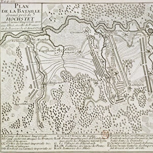
1747, La Feuille Map of France, topography, cartography, geography, land, illustration

![]()
Wall Art and Photo Gifts from Liszt Collection
1747, La Feuille Map of France, topography, cartography, geography, land, illustration
1747, La Feuille Map of France
Liszt Collection of nineteenth-century engravings and images to browse and enjoy
Media ID 14006629
© Artokoloro Quint Lox Limited
1747 Antique Map Atlas Chart Geographic Latitude Longitude Mappa Mundi Old Antique Plan Old Antique View Old Map Ols Antique Map Rare Old Maps Topo
FEATURES IN THESE COLLECTIONS
> Maps and Charts
> Early Maps
> Maps and Charts
> World
EDITORS COMMENTS
This print showcases the remarkable "1747, La Feuille Map of France" a true masterpiece in the realms of topography, cartography, and geography. With its intricate details and stunning accuracy, this vintage illustration takes us on a journey through time to explore the land and history of France. The map's geometric grid, latitude and longitude lines effortlessly guide our eyes across its ancient paper surface. Its decorative elements evoke a sense of nostalgia as we delve into the rich tapestry of French culture and heritage. This rare old map is not just an artistic creation but also a valuable tool for navigation and exploration. As we gaze upon this aged relic, we are transported back to an era when maps were meticulously hand-drawn with utmost precision. Each contour line represents the diverse topography that defines different regions within France. It serves as both a historical document and an invitation to discover the wonders that lie within this enchanting country. The "1747, La Feuille Map of France" from Liszt Collection captures not only the essence of cartographic artistry but also sparks our curiosity about how people perceived their world centuries ago. Let it inspire you to embark on your own personal journey through time as you immerse yourself in this fascinating glimpse into history's vast landscapes.
MADE IN AUSTRALIA
Safe Shipping with 30 Day Money Back Guarantee
FREE PERSONALISATION*
We are proud to offer a range of customisation features including Personalised Captions, Color Filters and Picture Zoom Tools
SECURE PAYMENTS
We happily accept a wide range of payment options so you can pay for the things you need in the way that is most convenient for you
* Options may vary by product and licensing agreement. Zoomed Pictures can be adjusted in the Cart.