Home > Maps and Charts > World
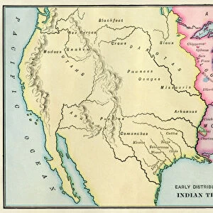
1873, Asher Adams Map of the Midwest, Ohio, Indiana, Illinois, Missouri, Kentucky

![]()
Wall Art and Photo Gifts from Liszt Collection
1873, Asher Adams Map of the Midwest, Ohio, Indiana, Illinois, Missouri, Kentucky
Liszt Collection of nineteenth-century engravings and images to browse and enjoy
Media ID 14006264
© Artokoloro Quint Lox Limited
1873 Illinois Indiana Kentucky Missouri Ohio Antique Map Atlas Chart Geographic Latitude Longitude Mappa Mundi Old Antique Plan Old Antique View Old Map Ols Antique Map Rare Old Maps Topo
FEATURES IN THESE COLLECTIONS
> Maps and Charts
> Early Maps
> Maps and Charts
> World
EDITORS COMMENTS
This print showcases a remarkable piece of history - the 1873 Asher Adams Map of the Midwest. With its intricate details and stunning craftsmanship, this map takes us back to a time when cartography was both an art form and a scientific endeavor. The map covers vast territories, including Ohio, Indiana, Illinois, Missouri, and Kentucky. Its topographic features provide an in-depth understanding of the region's landforms and geographic characteristics. The carefully plotted grid lines reveal latitude and longitude coordinates, allowing for precise navigation across these states. As we gaze upon this vintage masterpiece, we are transported to an era where exploration and discovery were paramount. It serves as a testament to the curiosity of our ancestors who sought to unravel the mysteries of their world through meticulous mapping. Printed on aged paper with an antique aesthetic, this historical artifact exudes charm and nostalgia. Its decorative elements make it not only informative but also visually appealing - truly a work of art that captures the essence of bygone times. Whether you're a geography enthusiast or simply appreciate rare old maps, this Asher Adams creation is sure to captivate your imagination. Let it transport you on a journey through time as you explore the rich history embedded within its delicate lines and intricate illustrations.
MADE IN AUSTRALIA
Safe Shipping with 30 Day Money Back Guarantee
FREE PERSONALISATION*
We are proud to offer a range of customisation features including Personalised Captions, Color Filters and Picture Zoom Tools
SECURE PAYMENTS
We happily accept a wide range of payment options so you can pay for the things you need in the way that is most convenient for you
* Options may vary by product and licensing agreement. Zoomed Pictures can be adjusted in the Cart.