Home > Maps and Charts > World
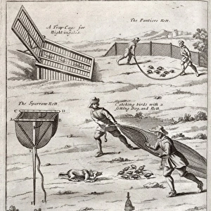
1873, U. S. Coast Survey Chart or Map of the Chesapeake Bay and Delaware Bay, topography

![]()
Wall Art and Photo Gifts from Liszt Collection
1873, U. S. Coast Survey Chart or Map of the Chesapeake Bay and Delaware Bay, topography
1873, U.S. Coast Survey Chart or Map of the Chesapeake Bay and Delaware Bay
Liszt Collection of nineteenth-century engravings and images to browse and enjoy
Media ID 14008061
© Artokoloro Quint Lox Limited
1873 Antique Map Atlas Chart Geographic Latitude Longitude Mappa Mundi Old Antique Plan Old Antique View Old Map Ols Antique Map Rare Old Maps Topo
FEATURES IN THESE COLLECTIONS
> Maps and Charts
> Early Maps
> Maps and Charts
> World
EDITORS COMMENTS
This print showcases a remarkable piece of history - the 1873 U. S. Coast Survey Chart or Map of the Chesapeake Bay and Delaware Bay. With its intricate topography, this map offers an intriguing glimpse into the past, revealing the detailed cartography and geography of these iconic bays. The carefully illustrated landforms and geographic features on this vintage map transport us to a bygone era when exploration and discovery were at their peak. The grid lines, latitude, longitude markings, and geometric precision add an element of scientific accuracy to this artistic representation. As we delve into its aged paper texture and retro aesthetic, we are reminded of the significance that maps held in navigating our world before modern technology took over. This historical artifact serves as a testament to mankind's insatiable curiosity about our planet's diverse regions. With its decorative elements reminiscent of ancient mappa mundi designs, this old antique view evokes a sense of wonderment for both history enthusiasts and avid travelers alike. It invites us to embark on a journey through time while appreciating the artistry involved in creating such rare old maps.
MADE IN AUSTRALIA
Safe Shipping with 30 Day Money Back Guarantee
FREE PERSONALISATION*
We are proud to offer a range of customisation features including Personalised Captions, Color Filters and Picture Zoom Tools
SECURE PAYMENTS
We happily accept a wide range of payment options so you can pay for the things you need in the way that is most convenient for you
* Options may vary by product and licensing agreement. Zoomed Pictures can be adjusted in the Cart.