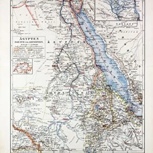
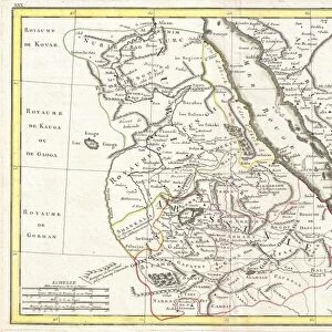
Photo Mug : 1818, Pinkerton Map of Nubia, Sudan and Abyssinia, John Pinkerton, 1758 - 1826, Scottish


![]()
Home Decor from Liszt Collection
1818, Pinkerton Map of Nubia, Sudan and Abyssinia, John Pinkerton, 1758 - 1826, Scottish
1818, Pinkerton Map of Nubia, Sudan and Abyssinia, John Pinkerton, 1758 - 1826, Scottish antiquarian, cartographer, UK
Liszt Collection of nineteenth-century engravings and images to browse and enjoy
Media ID 14004975
© Artokoloro Quint Lox Limited
1758 1826 1758 – 1826 17581826 1818 Cartographer John Pinkerton Scottish Antiquarian Antique Map Latitude Longitude Mappa Mundi Old Antique Plan Old Antique View Ols Antique Map Rare Old Maps Topo
Photo Mug
Add a touch of historical charm to your daily routine with our Media Storehouse Photo Mug featuring the 1818 Pinkerton Map of Nubia, Sudan, and Abyssinia. This antique map, created by Scottish cartographer John Pinkerton in 1818, showcases intricate details of the regions during the early 19th century. Bringing history to life, each mug is printed with high-quality, vibrant images from the Liszt Collection. Perfect for tea or coffee, these mugs make unique and thoughtful gifts for history enthusiasts and collectors.
A personalised photo mug blends sentimentality with functionality, making an ideal gift for cherished loved ones, close friends, or valued colleagues. Preview may show both sides of the same mug.
Elevate your coffee or tea experience with our premium white ceramic mug. Its wide, comfortable handle makes drinking easy, and you can rely on it to be both microwave and dishwasher safe. Sold in single units, preview may show both sides of the same mug so you can see how the picture wraps around.
Mug Size is 8.1cm high x 9.6cm diameter (3.2" x 3.8")
These are individually made so all sizes are approximate
EDITORS COMMENTS
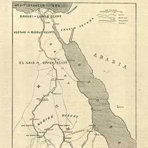
This print showcases the remarkable "1818, Pinkerton Map of Nubia, Sudan and Abyssinia" created by John Pinkerton, a Scottish antiquarian and cartographer. With meticulous detail and precision, Pinkerton skillfully crafted this map to depict the topography, geography, and land features of these regions in stunning clarity. The vintage allure of this ancient map is evident through its aged appearance on old paper. Its historical significance transports us back in time to an era when exploration and discovery were at their peak. This decorative piece serves as a testament to the artistry involved in early cartography. As we gaze upon this rare treasure from the past, we are reminded of the vastness of our world and how it has evolved over centuries. The intricate grid system with latitude and longitude lines adds a touch of geometric elegance to this illustration. Whether used for navigation or simply admired for its beauty, this antique map offers a glimpse into the rich history that shaped these regions. It invites us on a journey through time as we explore Nubia, Sudan, Abyssinia (now Ethiopia), and beyond. The Liszt Collection presents this print as an homage to John Pinkerton's legacy. It allows us to appreciate his contribution to geographic knowledge while also celebrating the enduring appeal of vintage maps. Let your imagination soar as you delve into the mysteries held within each contour line and landmark depicted on this extraordinary piece of cartographic art.
MADE IN AUSTRALIA
Safe Shipping with 30 Day Money Back Guarantee
FREE PERSONALISATION*
We are proud to offer a range of customisation features including Personalised Captions, Color Filters and Picture Zoom Tools
SECURE PAYMENTS
We happily accept a wide range of payment options so you can pay for the things you need in the way that is most convenient for you
* Options may vary by product and licensing agreement. Zoomed Pictures can be adjusted in the Cart.